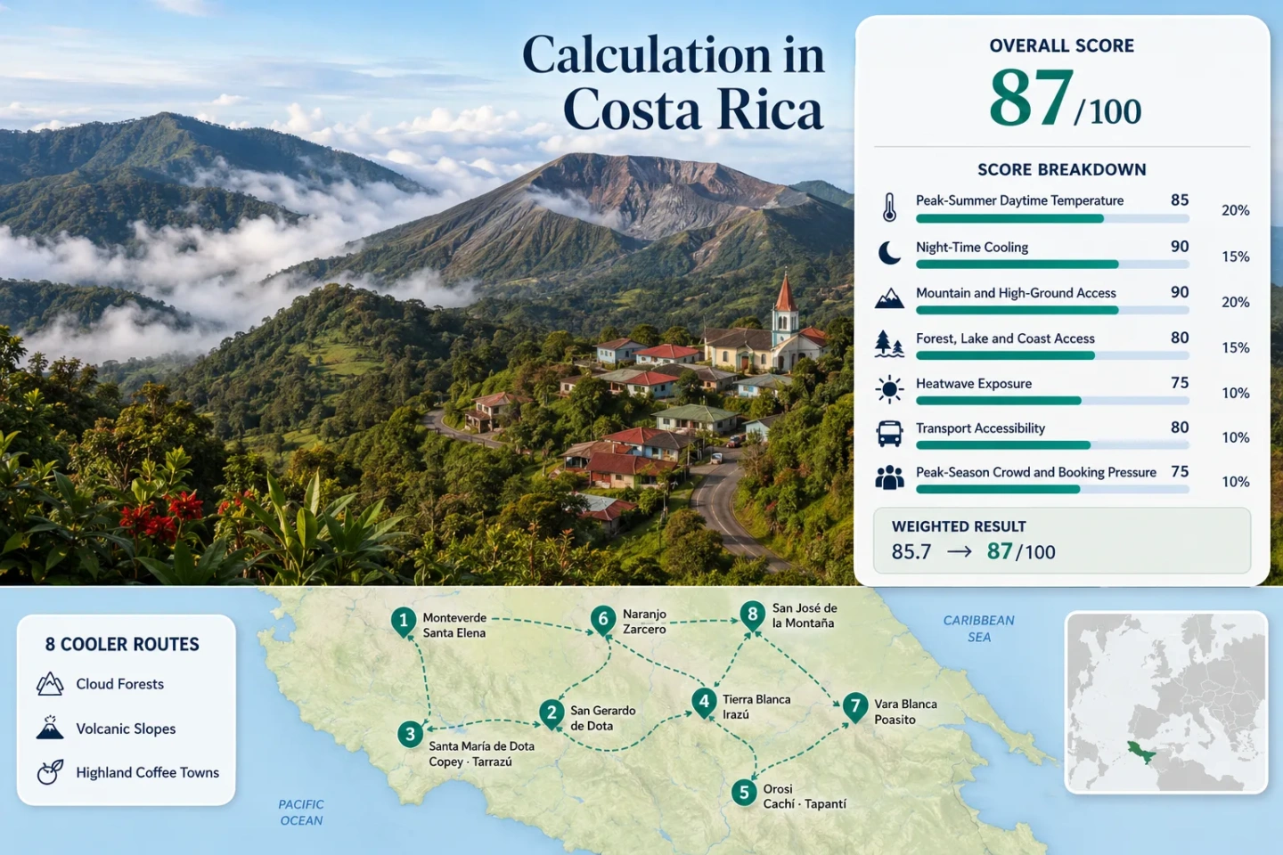
Costa Rica Cooler Routes: Cloud Forests, Volcano Slopes and Highland Coffee Towns
Costa Rica’s cooler travel corridors are concentrated above the lowlands, where cloud cover, elevation, forest shade and night cooling reshape the July–August heat load. Eight routes connect misty Monteverde, the upper Dota valleys, working coffee towns, volcanic roads and rain-fed highland forests; the trade-off is frequent rain, fog, wet roads and protected-area access that may change at short notice.
The portfolio uses the same eight corridors in the map, score calculation, route cards and comparison matrix.
Irazú is Costa Rica’s highest volcano; the exposed crater sector is far colder and windier than the overnight base around Tierra Blanca.
San Gerardo de Dota combines a roughly 2,200 m valley base, forest lodging and direct access to the Los Quetzales landscape.
About 1,600 m of elevation, persistent mist and reduced solar load create a damp form of cooling rather than dry mountain air.
Lower heat exposure is paired with wet-season road conditions; route-center climate proxies show roughly 17–22 rainy days per month across much of the set.
Volcano sectors require current status checks, while cloud-forest and waterfall roads can lose visibility before the pavement itself becomes difficult.
Cloud-Forest Ridges, Volcano Roads and Coffee Valleys
The markers connect overnight bases and central planning points for the eight cooler corridors. They do not identify guaranteed legal parking, exact viewpoints or individual trailheads.
Markers use approximate public settlement or route centers for planning orientation. Open each route card for a Google Maps search link and access notes before traveling.
Costa Rica Highland Cooler Escape Suitability Score
This is a transparent editorial suitability index based on disclosed climate, landscape, access and pressure factors. It is not an official climate classification or a weather forecast. Route count does not add a score bonus; each factor uses the median of the same eight routes.
Weighted total: 97×0.25 + 100×0.20 + 100×0.15 + 75×0.15 + 98×0.10 + 70×0.10 + 70×0.05 = 90.8 → 91/100
Eight Highland Corridors from Monteverde to Dota
The route cards separate the overnight base, main daytime corridor and highest optional point. This prevents a cold summit stop from being treated as equivalent to a town where the cooler conditions continue through the evening and night.
Monteverde–Santa Elena
Mist, wind and low solar exposure carry more of the cooling load than extreme altitude. Santa Elena works as the service base, while the reserve roads and forest edges create the dampest route in the set. Clothing can stay wet even when rain is light.
Watch for: Fog can remove ridge views quickly, and popular reserves concentrate visitors during the same morning window.
San Gerardo de Dota–Los Quetzales
A roughly 2,200 m overnight base gives this route the clearest night-cooling advantage. The Savegre Valley holds forest lodges, river access and cloud-forest trails without requiring a return to a warmer lowland town after sunset.
The approach leaves Ruta 2 near Cerro de la Muerte and descends into a narrow valley. That final descent is part of the route character: cooler air and forest lodging come with steep grades, cloud and limited passing space. Arrival before dark is the safer rhythm.
Works for: Travelers who value cool nights, a quiet base and direct forest access more than quick connections between towns.
Santa María de Dota–Copey–Tarrazú
Town altitude: Copey is listed at 1,853 m, while the wider Los Santos coffee zone spans roughly 1,200–1,900 m.
Climate proxy: Santa María averages 20.3°C for July–August daily maxima and about 14.5°C for minima.
Road character: A connected working-town network rather than an isolated forest lodge corridor.
Rain trade-off: The Santa María grid records 347 mm in July and 428 mm in August.
Coffee fields explain the elevation pattern, but the route should not be reduced to farm visits. Its stronger value is practical: bakeries, markets, fuel and town lodging sit inside a highland corridor where evening temperatures fall without the exposed wind of a volcano summit.
Santa María and Copey provide the calmer overnight rhythm; San Marcos de Tarrazú adds more services and daytime movement.
Tierra Blanca–Irazú–Prusia
The route contains three different temperature zones. Tierra Blanca is the agricultural and meal base. The crater sector is an exposed, short-duration high point. Prusia is the forested walking sector where shade and shelter matter more than crater views.
The inhabited-slope proxy near Pacayas is around 22°C by day and 15°C at night in July–August. The crater can be much colder, yet it should not define the whole route score because most visitors do not sleep there and access can be affected by weather or park controls.
Orosi–Cachí–Tapantí
This is the softer highland option. Orosi is lower than Dota or the volcano roads, but river air, shaded slopes and the wet forest toward Tapantí reduce the daytime heat load. The climate proxy sits near 22.3°C by day and 16.3°C at night in July–August.
Orosi Valley and Cachí add water and open valley views.
Both July and August reach about 20 rainy days in the route-center grid.
The valley is straightforward; Tapantí needs a current park and road check.
Humidity can offset part of the temperature advantage. The route suits shaded walks and river scenery more than dry, crisp mountain air.
Naranjo–Zarcero–Palmira
Accessibility is the route’s main advantage. Naranjo and Zarcero connect through the Western Valley without a remote park road or deep mountain-valley descent. The cooler effect is milder than Dota, Vara Blanca or Irazú, but town services remain close throughout the drive.
The route crosses from coffee slopes into cooler farm country. July’s mid-year rainfall recession can improve visibility on some days, but it is not a dry-season guarantee. Short showers, cloud and wet pavement remain normal.
Good for: A short highland circuit with strong town access and less dependence on a national-park entry.
Vara Blanca–Poasito–Bajos del Toro
Vara Blanca proxy: 20.1–20.5°C maxima and 15.0°C minima across July–August.
Bajos del Toro proxy: 20.9–21.2°C maxima, 15.5°C minima and about 21 rainy days per month.
Route form: Wet ridge, roadside viewpoints, private waterfall access and dispersed rural lodging.
Vehicle value: High, because individual stops are spread across mountain roads.
Poás is an optional branch rather than the load-bearing reason to use this corridor. If the crater sector has no suitable entry, poor visibility or a status change, Vara Blanca, Cinchona and Bajos del Toro still form a coherent wet-highland route.
Watch for: Heavy rain can make a nominally paved road tiring long before it becomes impassable.
San José de la Montaña–Sacramento–Barva Highlands
The route rises through settled Heredia highlands before reaching the Barva sector of Braulio Carrillo National Park. Sacramento’s July–August proxy is about 21.0°C by day and 15.5°C at night, while the volcanic high ground reaches roughly 2,906 m.
The lower approach and the park approach are separate decisions. San José de la Montaña and Sacramento can still provide a cool rural drive when the final road, rain or entry conditions make the upper sector unsuitable.
A higher-clearance vehicle may add confidence on the final approach, but current local road information matters more than a blanket four-wheel-drive rule.
Open San José de la Montaña–Sacramento–Barva Highlands in Google Maps
Which Corridor Matches the Cooling Need?
The same eight routes are compared by overnight base, July–August climate proxy, cooling mechanism, car dependence and the trade-off most likely to alter the trip.
| Route | Overnight base | July–August proxy | Main cooling mechanism | Car dependence | Main trade-off |
|---|---|---|---|---|---|
| Monteverde–Santa Elena | Santa Elena or Monteverde ridge lodging | 24.2°C / 18.5°C | Mist, wind and reduced solar load | Medium-high | Dampness, fog and concentrated reserve traffic |
| San Gerardo de Dota–Los Quetzales | San Gerardo de Dota | 20.1°C / 14.7°C | High valley and night cooling | High | Steep valley access and heavy wet-season rain |
| Santa María de Dota–Copey–Tarrazú | Santa María, Copey or San Marcos | 20.3°C / 14.5°C | Highland town nights | Medium | Sunny breaks can warm exposed coffee slopes |
| Tierra Blanca–Irazú–Prusia | Tierra Blanca or Cartago-area lodging | 22.2°C / 15.3°C inhabited-slope proxy | Elevation, summit wind and forest shade | Medium | Rapid weather change, UV and timed park entry |
| Orosi–Cachí–Tapantí | Orosi or Cachí | 22.3°C / 16.3°C | River valley, forest shade and rain | Medium | High humidity and frequent afternoon rain |
| Naranjo–Zarcero–Palmira | Zarcero or Naranjo | 23.4°C / 17.5°C | Moderate elevation and farm-country nights | Low-medium | Less dramatic temperature drop than upper Dota |
| Vara Blanca–Poasito–Bajos del Toro | Vara Blanca or Bajos del Toro | 20.7°C / 15.3°C route average | Wet ridge, forest and waterfalls | High | Heavy rain, dispersed stops and changing Poás access |
| San José de la Montaña–Sacramento–Barva Highlands | Sacramento or lower Heredia highlands | 21.0°C / 15.5°C | Cloud forest and volcanic elevation | High for upper sector | Final road condition and limited upper-sector services |
Why Monteverde Mist, Irazú Wind and Dota Nights Feel Different
A lower thermometer reading is only one part of highland comfort. Costa Rica’s central ranges produce four distinct forms of cooling, each with a different cost.
Monteverde’s Cloud-Cooled Ridge
Persistent cloud reduces direct sun and wind removes heat from exposed ridges. The air is not as cold as Irazú, but damp skin and wet clothing can make the route feel cooler than the daily maximum suggests.
Irazú’s Summit-Cooled Exposure
Elevation and wind create the strongest short-duration temperature drop. There is little shelter on the crater side, and high UV can remain strong even when jackets are needed.
Dota’s Valley Night Cooling
San Gerardo and the Los Santos towns hold cooler evening and morning temperatures where people actually sleep. This matters more for a multi-night heat escape than a brief summit stop.
Orosi and Bajos del Toro’s Wet-Forest Cooling
Rivers, waterfall valleys and dense shade reduce solar load. Humidity is the price: the temperature is moderate, yet clothing dries slowly and strenuous walks can still feel heavy.
Cerro de la Muerte and Volcano Summits Are Not Overnight Bases
The coldest point on a route is not always the most useful place to stay. Separating the base, main daytime corridor and optional high point produces a more realistic plan.
| Corridor | Overnight base | Main daytime band | Highest optional point | Planning consequence |
|---|---|---|---|---|
| Upper Dota | San Gerardo de Dota, about 2,200 m | Savegre Valley forest and river trails | Cerro de la Muerte road corridor, about 3,451 m at Buena Vista | The cool night remains at the lodging base; the highest road is not required for the route to work. |
| Irazú slopes | Tierra Blanca and nearby agricultural towns | Prusia forest and upper volcano road | Irazú summit, 3,432 m | Summit cold is brief and exposed; meals, lodging and evening comfort sit lower. |
| Barva highlands | San José de la Montaña or Sacramento | Cloud-forest approach and rural highland roads | Barva volcanic high ground, about 2,906 m | The final road and park entry can be removed without losing the lower highland drive. |
| Monteverde ridge | Santa Elena | Reserve roads around the settled cloud-forest ridge | Exposed ridges rather than a single summit | Cloud and wind drive comfort; chasing the highest point adds little. |
Poás Is an Optional Branch, Not the Vara Blanca Route
SINAC lists Poás in its online reservation system, and OVSICORI maintains live volcanic monitoring and crater cameras. Neither a reservation listing nor a camera image guarantees suitable access or visibility on a specific morning.
Entry Available and Visibility Usable
Use the crater sector as an early branch, then continue through Poasito and Vara Blanca. The high point adds a sharp temperature contrast but should not consume the entire day.
Entry Available but the Crater Is Clouded
Keep the reserved slot if the volcanic and weather notices remain suitable, but treat the visit as a high-elevation stop rather than a guaranteed crater view.
No Suitable Entry or a Status Change
Continue with Vara Blanca, Cinchona and Bajos del Toro. Waterfalls, wet forest and cool ridge settlements preserve the route’s cooling logic without the national-park branch.
Current checks: SINAC reservations, Poás park information and OVSICORI crater camera.
July–August: Pacific-Slope Rainfall Recession, Wet Ridges and Afternoon Risk
Costa Rica’s mid-year rainfall recession can improve some Pacific-slope mornings, especially around parts of the Western and Central valleys. It does not produce one national dry window. The wet ridges around Vara Blanca, Tapantí and upper Dota retain frequent rain.
July on Monteverde, Dota and Zarcero Slopes
Santa Elena’s grid drops from 298 mm in June to 204 mm in July, and Santa María drops from 464 mm to 347 mm. Zarcero studies also identify a mid-year rainfall recession. Morning visibility may improve, but 17–22 rainy days remain possible in the route-center datasets.
August Often Rebuilds the Wet-Season Load
Rain totals rise from July to August in Santa Elena, San Gerardo, Santa María, Orosi, Sacramento and Vara Blanca. Earlier starts become more useful as cloud and showers rebuild later in the day.
Vara Blanca and Tapantí Do Not Follow a Simple Pacific Pattern
Moisture reaches these slopes from different directions and local terrain amplifies rainfall. A July rainfall recession elsewhere should not be used to assume dry waterfall roads or clear forest views.
Rain Helps Night Cooling but Complicates Drying
Cloud, wet ground and elevation keep nights mild to cool across the upper routes. The same moisture can leave boots, jackets and vehicle interiors damp for the next morning.
Practical timing: Put volcano views, exposed ridges and longer drives early. Reserve shaded forest, town meals and short waterfall stops for the more cloud-prone afternoon.
Live Checks Before a Highland Drive
IMN Rain and Wind Notices
Regional forecasts and active meteorological notices matter more than a country-wide icon. Heavy rain, trade-wind surges and local thunderstorms can affect opposite slopes differently.
Check the IMN regional forecast and current meteorological notices.
SINAC Sector and Reservation Status
Poás, the Irazú crater and Prusia sectors, the Barva sector and Tapantí appear in the SINAC online system. Verify the exact sector, date and entry time rather than assuming one reservation covers the whole route.
OVSICORI Volcanic Monitoring
Volcanic conditions and visitor access are separate systems. OVSICORI monitoring supports the hazard check; SINAC controls visitor entry. Both should be reviewed for Poás and other volcanic sectors.
Mountain weather, road visibility and protected-area status can change within the same day. Exact parking, trailhead and road-surface decisions require current local confirmation.