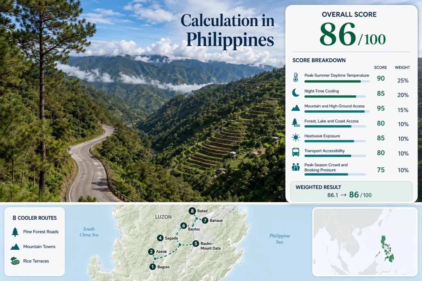
Philippines Highland Escapes: Cordillera Towns, Pine Roads and Mountain Terraces
Northern Luzon’s Cordillera trades lowland heat for altitude, pine-lined roads and terraced valleys. April and May offer the clearest heat-relief logic, but conditions vary sharply: Atok and the Mount Data corridor occupy the coolest elevation band, while Bontoc and the Ifugao terrace bases depend more on evening cooling after warmer afternoons.
A city base, pine-road municipalities, mountain transit towns and two living terrace landscapes.
The highlands provide their strongest contrast with the hotter Central Luzon and Manila approaches during the late dry season.
The elevated Benguet road corridor produces the lowest daytime temperature proxy in the selected route set.
The route links Baguio with Atok, Bauko, Sagada and Bontoc through steep elevation changes and fog-prone passes.
Ifugao’s amphitheater-like rice terraces add cultural depth, foot access and a warmer, wetter highland climate.
Visibility can deteriorate quickly on high roads, while heavy rain raises landslide and delay risk from June into October.
Cordillera Spine from Baguio to the Ifugao Terraces
The eight markers follow the main highland progression from the pine city of Baguio through Benguet and Mountain Province to the Banaue and Batad terrace valleys.
Markers show selected highland planning centers, not guaranteed legal parking areas, trailheads or exact viewpoints. Use the route-specific Google Maps links and current local access information before traveling.
Philippine Cordillera Cooler Escape Suitability Score
The index measures the selected Cordillera route set through disclosed climate, high-ground, natural-access, transport and peak-pressure factors. It is an editorial suitability index rather than an official climate classification or weather forecast.
Highland advantage: Elevation, widespread mountain access and cooler nights offset weaker road resilience, uneven public transport and holiday-period pressure.
Method: The April–May weighted mean maximum at Baguio’s PAGASA station was calculated from the 1991–2020 monthly normals and adjusted to each planning-base elevation using a 6.5°C-per-kilometer standard atmospheric lapse-rate proxy. The route median was normalized with the fixed daytime-temperature scale.
Raw factor value: Median estimated daily maximum 26.1°C, producing 65/100.
Route values: Baguio 25.1°C; Atok 20.5°C; Kabayan 27.0°C; Sagada 25.1°C; Bauko–Mount Data 24.4°C; Bontoc 29.0°C; Banaue 27.0°C; Batad 27.7°C.
Station mapping: Baguio uses the direct station at approximately 1,510 m. The other seven values are representative-station proxies adjusted from Baguio to approximate route-center elevations. Atok is roughly 40 km north with a planning base about 700 m higher; Kabayan about 55 km northeast with a base about 300 m lower; Sagada about 80 km north at a similar elevation; Bauko–Mount Data about 70 km north with its planning base around 100 m higher; Bontoc about 90 km northeast and around 600 m lower; Banaue about 115 km northeast and around 300 m lower; Batad about 120 km northeast and around 400 m lower. The cited PAGASA table does not publish a station code.
Period: PAGASA 1991–2020 climate normals; April and May weighted by calendar days.
Sources: PAGASA Baguio climatological normals; NASA standard-atmosphere temperature relationship.
Method: The Baguio April–May weighted mean minimum was adjusted to the same eight route elevations. The route median was normalized against the fixed night-cooling scale, which favors average minima between 10°C and 16°C without rewarding unusually cold nights.
Raw factor value: Median estimated daily minimum 17.2°C, producing 91/100.
Route values: Baguio 16.2°C; Atok 11.6°C; Kabayan 18.1°C; Sagada 16.2°C; Bauko–Mount Data 15.5°C; Bontoc 20.1°C; Banaue 18.1°C; Batad 18.8°C.
Source mapping and rationale: The direct Baguio station is used for Baguio. Every other route uses the same representative station and elevation relationship disclosed for the daytime factor, preserving a consistent baseline rather than mixing incompatible commercial weather summaries.
Period: PAGASA 1991–2020 climate normals; April and May weighted by calendar days.
Sources: PAGASA Baguio climatological normals; PAGASA climate and elevation context; NASA standard-atmosphere relationship.
Method: Each route was classified with the fixed elevation-access rubric. A score of 100 requires a lodging base at or above 900 m or routinely reachable ground above 1,500 m within approximately 60 minutes.
Raw factor value: Route-score median 100, producing 100/100.
Route scores: Baguio 100 — city base near 1,500 m; Atok 100 — high-road base near 2,200 m; Kabayan 100 — base around 1,200 m with access toward Mount Pulag’s 2,922 m summit zone; Sagada 100 — town around 1,500 m; Bauko–Mount Data 100 — high municipality and pass corridor; Bontoc 100 — base around 900 m with immediate mountain roads; Banaue 100 — base around 1,200 m; Batad 100 — highland village and surrounding terrace slopes.
Source mapping and rationale: PAGASA documents Baguio’s high-elevation climate station; Sagada’s official tourism portal gives an elevation around 1,500 m; Atok’s municipal information describes its high-elevation setting; the Mount Pulag management plan records park elevations from about 1,100 m to 2,922 m; provincial and national tourism sources establish the mountain setting of Mountain Province and Ifugao.
Period: Access and geographic status reviewed July 21, 2026.
Sources: PAGASA Baguio station information; Sagada Tourism Office; Municipality of Atok; DENR Mount Pulag management plan; Mountain Province geography.
Method: The fixed physical-access rubric was applied to forests, large river systems and other substantial water or coastal features. The score measures practical proximity rather than scenic reputation.
Raw factor value: Route-score median 75, producing 75/100.
Route scores: Baguio 75 — immediate pine-forest and watershed access; Atok 75 — mountain forest and agricultural slopes; Kabayan 100 — Mount Pulag forest zones plus river-valley access; Sagada 100 — pine forest, caves and river systems; Bauko–Mount Data 75 — high forest and headwater landscape; Bontoc 75 — Chico River valley and mountain vegetation; Banaue 75 — forested watershed and terrace irrigation landscape; Batad 75 — forested slopes and terrace-water system.
Source mapping and rationale: DENR documents Mount Pulag’s forest and protected-area systems. Mountain Province sources describe the province’s mountainous watersheds, while Department of Tourism and UNESCO materials establish the physical terrace-water landscapes of Banaue and Batad.
Period: Physical access reviewed July 21, 2026.
Sources: DENR Mount Pulag protected-area material; Mountain Province geography; Department of Tourism Ifugao profile; UNESCO Philippines World Heritage sites.
Method: A conservative threshold-frequency proxy was derived from the elevation-adjusted April–May maximum-temperature estimates and Baguio’s official monthly extreme-temperature record. It estimates relative exposure to 30°C-or-higher afternoons across the route set. No exact daily-count series is claimed.
Raw factor value: Median estimated 30°C-or-higher exposure 2.5%, producing 88/100.
Route proxy values: Baguio 1%; Atok 0.5%; Kabayan 4%; Sagada 1%; Bauko–Mount Data 1%; Bontoc 12%; Banaue 4%; Batad 7%.
Source mapping and limitation: PAGASA’s Baguio extreme table records the station’s historical April maximum at 30.0°C and May maximum at 29.4°C through 2025. Public, complete daily series covering the same ten recent April–May periods were not available for all eight route centers. The estimates therefore express comparative exposure bands, not observed daily counts, and comparability is classified C.
Period: PAGASA 1991–2020 normals combined with official monthly extremes through 2025.
Sources: PAGASA Baguio climatological extremes through 2025; PAGASA Baguio climatological normals.
Method: Each base was scored with the fixed transport rubric, emphasizing direct scheduled service, transfer count, local mobility and whether a private vehicle is needed for the main experience.
Raw factor value: Route-score median 80, producing 80/100.
Route scores: Baguio 100 — frequent direct intercity buses and usable city transport; Atok 80 — served from Baguio along the Halsema corridor, though local stops require planning; Kabayan 40 — longer and less frequent onward connections, with private or arranged transport useful; Sagada 100 — direct coach options from Metro Manila plus Baguio connections; Bauko–Mount Data 80 — provincial bus and van corridor; Bontoc 80 — established provincial transport hub but long journey times; Banaue 100 — direct overnight coach service from Metro Manila; Batad 60 — Banaue transfer followed by local road transport and a walking approach.
Source mapping and rationale: Victory Liner publishes Baguio service information. Coda Lines lists direct Manila routes to Banaue, Bontoc and Sagada. The Sagada Tourism Office and Mountain Province government describe Baguio–Sagada and Baguio–Bontoc road connections.
Period: Published route availability reviewed July 21, 2026; schedules remain subject to operator changes and road conditions.
Sources: Victory Liner; Coda Lines route information; Sagada Tourism Office transport information; Mountain Province access information.
Method: The fixed pressure rubric was applied using official visitor-registration systems, permit requirements, accommodation concentration, transport capacity and the known concentration of Philippine holiday travel in April.
Raw factor value: Route-score median 60, producing 60/100.
Route scores: Baguio 20 — large accommodation supply but intense Holy Week and weekend demand; Atok 60 — smaller lodging base and roadside attraction pressure; Kabayan 60 — permit and trail-capacity constraints around Mount Pulag; Sagada 40 — registration, guided-activity rules and limited town capacity; Bauko–Mount Data 80 — lower concentration of leisure demand; Bontoc 80 — regional hub with less resort-style booking pressure; Banaue 60 — concentrated terrace tourism and long-distance coach demand; Batad 60 — limited village lodging and constrained last-mile access.
Source mapping and rationale: Baguio’s VISITA system provides an official accommodation and visitor-planning framework. Sagada operates a municipal tourism-registration system. DENR documents permit-controlled Mount Pulag access. Ifugao’s tourism profile confirms the concentration of visitor interest around the terrace clusters.
Period: Current systems and capacity patterns reviewed July 21, 2026. Comparable route-level occupancy statistics were not published for the complete set, supporting comparability class C.
Sources: Baguio VISITA; Sagada Tourism Office; DENR Mount Pulag management material; Department of Tourism Ifugao profile.
Weighted calculation
Route count does not add a score bonus. Each route carries equal weight, and factor values use the route median before normalization.
Pine Roads, High Towns and Living Terrace Valleys
The route set moves through three distinct Cordillera experiences: an accessible pine city, higher and quieter road settlements, and Ifugao communities where steep footpaths and irrigated terraces replace the broad mountain highway.
Baguio: Car-Light Pine-City Base
Baguio is the easiest Cordillera entry for travelers who want highland air without immediately committing to remote mountain roads. Pine parks, a large accommodation market and frequent bus connections make a private vehicle optional within the city.
The trade-off is density. April weekends and Holy Week can bring traffic, crowded public spaces and strong lodging demand. The city also sits lower than Atok, so midday warmth can still build despite much cooler nights than the lowlands.
Atok: The Highest Cool-Air Band
Atok lies roughly 40 km north of Baguio along the Halsema corridor, but its planning base rises to approximately 2,200 m. The resulting April–May proxies—about 20.5°C by day and 11.6°C at night—are the lowest in the assessed set.
Enough elevation to produce a noticeably cooler daytime band.
Fog, sharp bends and roadside stops make daylight travel preferable.
Vegetable terraces, high ridges and cloud movement define the route more than urban attractions. Accommodation and evening services are limited compared with Baguio, making Atok more effective as a deliberate high-road stay than an improvised late-night stop.
Kabayan: Pulag Access beyond the Main Spine
Kabayan’s town-level afternoon proxy is warmer than Atok’s, yet its strategic value comes from access toward Mount Pulag. The protected area spans elevations from roughly 1,100 m to 2,922 m, allowing a route to move into substantially cooler forest and grassland zones.
That high-ground advantage requires more planning than a casual road stop. Registration, protected-area rules, trail capacity and transfer arrangements should be resolved before leaving the principal highway corridor.
Sagada: Forest Town with Direct Coach Access
Sagada combines a town elevation near 1,500 m with pine forest, cave systems and river-cut terrain. Its April–May estimates of about 25.1°C by day and 16.2°C at night create a balanced highland climate rather than Atok’s colder, more exposed road environment.
Official local information describes the journey through the Halsema Highway corridor.
Direct Metro Manila coaches and local guided activities reduce private-car dependence.
The town’s popularity creates booking pressure during Philippine holidays. Tourism registration and guided-activity procedures also mean that arrival timing matters, particularly when a late bus arrival would leave little time to organize the next day.
Bauko–Mount Data: Pass-Country without Resort Crowds
Bauko and the Mount Data corridor occupy a high, transitional section between Benguet and the Sagada–Bontoc area. The route retains pine-road character and strong night cooling but usually receives less concentrated leisure traffic than Baguio or Sagada.
Its strength is route rhythm rather than a dense attraction cluster. A daylight stop or overnight break can shorten the mountain journey and reduce pressure to complete the entire Halsema stretch in one movement.
Bontoc: Warmer River-Valley Transport Hub
Bontoc is the principal administrative and transport center of Mountain Province. Its lower planning elevation of roughly 900 m produces the warmest April–May profile in the set: approximately 29.0°C by day and 20.1°C at night.
The Chico River valley loses part of the cooling advantage found on higher passes.
Useful for changing between Sagada, Banaue and other Mountain Province services.
Bontoc works better as a logistical hinge than as the route’s lowest-heat destination. Early starts and higher daytime excursions preserve comfort, while the town’s services make it practical when transport reliability matters more than holding the highest elevation.
Banaue: Accessible Base for Ifugao Terrace Country
Banaue provides the most practical service base for the Ifugao terrace clusters. Direct coach links from Metro Manila, a larger lodging selection and local transfers make it easier to organize than Batad, though the town is warmer and more humid than the high Benguet road.
Terrace appearance follows agricultural cycles and rainfall rather than a fixed tourism calendar. April–May offers lowland heat relief and generally easier road planning, while the greener wet-season landscape comes with heavier rain, cloud and slope instability.
Batad: Amphitheater Terraces beyond the Road
Batad exchanges transport convenience for an immersive terrace setting. The planning center sits around 1,100 m, with estimated April–May temperatures near 27.7°C by day and 18.8°C at night. It is cooler than the Philippine lowlands but not as cold as Atok or the Mount Data corridor.
The village experience involves steep paths and substantial elevation change on foot.
Holiday and weekend arrivals should not depend on finding an unplanned room.
The terrace bowl can feel humid during still afternoons, while evening cooling improves comfort after the walking day. Heavy rain changes the calculation quickly because stone steps, terrace edges and access paths become more slippery.
Why the Halsema Highway Changes Character after Atok
The Baguio–Atok–Bauko–Sagada road is not a uniform mountain drive. Elevation, exposure and settlement density change repeatedly, affecting temperature, visibility and the amount of daylight needed for a comfortable journey.
Baguio to Atok: The Main Temperature Drop
The road gains roughly 700 m between Baguio’s planning elevation and the higher Atok corridor. That difference produces the strongest modeled temperature reduction in the route set, with Atok about 4.6°C cooler by day than Baguio under the common elevation proxy.
Vegetable-transport traffic, roadside stopping and fog can still slow the journey. The cooling benefit therefore comes with a more demanding road environment.
Mount Data and Bauko: High Pass Transition
The road remains elevated but becomes less urban and more service-sparse. Bauko–Mount Data is useful for breaking the journey before Sagada or Bontoc, particularly when a late departure from Baguio would otherwise force high-road driving after dark.
Daylight is part of the comfort calculation. Cooler air does not compensate for poor visibility, fatigue or uncertainty about the next fuel, meal or lodging stop.
Sagada to Bontoc: Cooler Ridge to Warmer Valley
The descent toward Bontoc moves from Sagada’s approximately 1,500 m setting toward a river-valley base around 900 m. The modeled daytime difference approaches 4°C, explaining why Bontoc can feel noticeably warmer even though both towns belong to Mountain Province.
Bontoc compensates with transport and administrative services, making it a practical interchange when route continuity matters more than holding the coolest altitude.
Terrace Water, Afternoon Heat and Foot Access in Banaue and Batad
The Ifugao section operates differently from the Benguet pine-road corridor. Irrigated slopes, deep valleys and village footpaths create a greener but warmer and more physically demanding highland experience.
Banaue Holds the Services
Banaue concentrates transport arrivals, lodging, meals and local-transfer arrangements. Its approximate 1,200 m elevation still reduces lowland heat, but the 27.0°C daytime proxy is substantially warmer than Atok’s 20.5°C estimate.
A two-base itinerary can therefore use Banaue for logistics and Batad for the more immersive walking day, rather than treating both as interchangeable terrace stops.
Batad Depends on the Path Condition
Vehicle access does not remove the need for steep walking. Stable footwear, daylight and realistic baggage choices matter more than they do in Baguio, Sagada or Bontoc.
During sustained rain, the terrace steps and village approaches can become slippery. Recent restoration work following storm damage also underlines that the landscape is an active agricultural and engineered water system rather than a static viewing platform.
Heat-relief trade-off: The terrace valleys provide cooler nights than the lowlands, but their daytime comfort is weaker than the highest Benguet routes. Early walking hours and shaded breaks become more important in April and May.
Eight Cordillera Bases by Heat Relief, Access and Road Exposure
The comparison uses the same eight bases included in the map and suitability calculation. Temperature figures are planning proxies rather than route-level observations.
| Route | Planning Base | April–May Day / Night | Public Transport Pattern | Wet-Season Exposure | Primary Trade-Off |
|---|---|---|---|---|---|
| Baguio | ≈1,500 m | 25.1°C / 16.2°C | Frequent direct intercity buses; car-light city stay | Heavy rain and urban traffic disruption | Strong services but intense holiday congestion |
| Atok | ≈2,200 m | 20.5°C / 11.6°C | Buses and vans from Baguio along the highway | Fog, low visibility and slope delays | Lowest heat with limited evening services |
| Kabayan | ≈1,200 m | 27.0°C / 18.1°C | Infrequent onward connections; arranged transfer useful | Mountain-road and trail-condition sensitivity | Exceptional high-ground access with added logistics |
| Sagada | ≈1,500 m | 25.1°C / 16.2°C | Direct Metro Manila coach and Baguio connections | Fog and landslide disruption on approach roads | Balanced climate but registration and booking pressure |
| Bauko–Mount Data | ≈1,600 m | 24.4°C / 15.5°C | Provincial bus and van corridor | Exposed passes, fog and sparse roadside services | Quiet high road with fewer visitor facilities |
| Bontoc | ≈900 m | 29.0°C / 20.1°C | Regional transport interchange | River-valley heat plus road-delay risk | Useful connections but weakest heat relief |
| Banaue | ≈1,200 m | 27.0°C / 18.1°C | Direct overnight coach and local transfers | Heavy rain, cloud and slope instability | Strong services with warmer terrace-valley afternoons |
| Batad | ≈1,100 m | 27.7°C / 18.8°C | Banaue transfer followed by local transport and walking | Slippery paths and constrained last-mile access | Immersive terrace setting with limited mobility |
April Heat Relief versus June–October Terrace Green
No single period maximizes cool air, road reliability, terrace color and low visitor pressure at the same time. The practical window depends on which trade-off carries the most weight.
February–March: Drier Roads and Cooler Nights
These months generally favor clearer mountain-road planning and lower night temperatures. Terrace appearance varies with local planting cycles, while the highest settlements can feel cold before sunrise.
Useful for: Road-focused itineraries, long-distance views and travelers who place reliability above the greenest terrace conditions.
April–May: Strongest Contrast with Lowland Heat
The selected scoring window aligns with the period when Manila and the Central Luzon approaches can feel much hotter. Atok, Sagada and Mount Data preserve substantial night cooling, while Bontoc and the terrace valleys experience warmer afternoons.
Watch for: Holy Week congestion, higher lodging demand and the transition toward more frequent May rain.
June–October: Greener Slopes with Higher Disruption Risk
Rain supports greener terraces and cloud-rich mountain scenery, but it also increases fog, landslide exposure, road delays and slippery footpaths. Sagada’s official travel information specifically warns about rainy-season road conditions during this period.
Good fit: Flexible itineraries with spare days, daylight transfers and willingness to change routes when local road advisories deteriorate.
Two Live Checks before a Cordillera Transfer
Weather and Mountain-Road Status
PAGASA forecasts should be checked together with current provincial, municipal and road-agency advisories. A dry forecast in Baguio does not guarantee clear visibility or open conditions farther north on the Halsema corridor.
Decision point: Delay a long transfer when heavy rain, landslide reports or dense high-road fog would push arrival beyond daylight.
Permits, Registration and Local Capacity
Mount Pulag access requires protected-area planning, while Sagada activities operate through local tourism procedures. Small-scale lodging in Atok and Batad also warrants advance confirmation during holiday periods.
Decision point: Secure the regulated or capacity-limited part of the route before purchasing tightly connected transport segments.
Most balanced route pattern: Begin with Baguio for transport recovery, move through Atok and the Mount Data corridor in daylight, use Sagada or Bontoc as the Mountain Province base, and reserve Banaue–Batad for a separate terrace segment with enough time for weather-related changes.