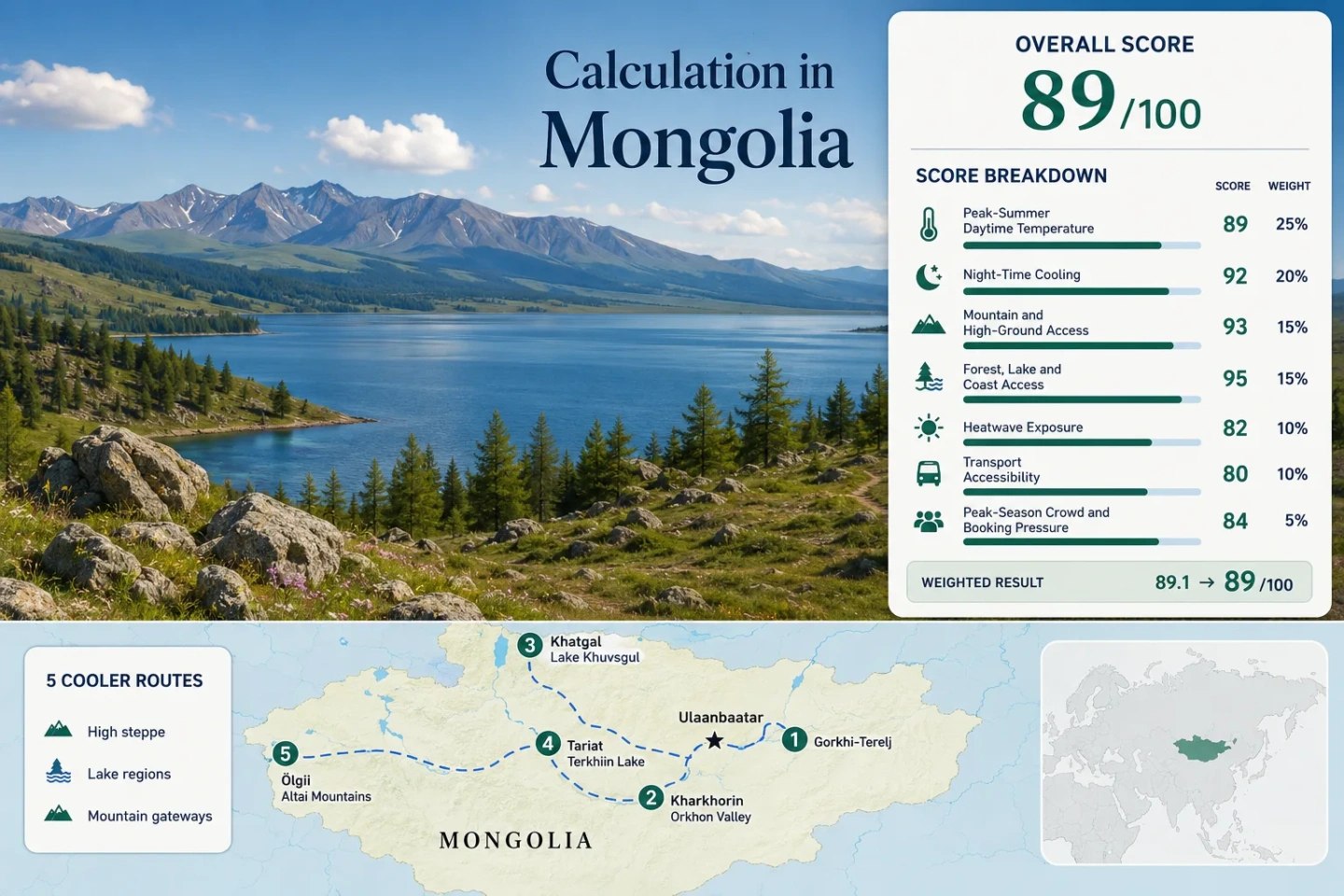
Mongolia Cooler Summer Travel: High Steppe, Lakes and Open-Sky Escapes
Mongolia’s cooler summer routes are shaped less by latitude alone than by high settlement bases, dry continental air, rapid night-time heat loss and access to northern lakes or mountain plateaus. The strongest July–August options extend from the granite-and-forest valleys east of Ulaanbaatar to Lake Khuvsgul, the volcanic Khangai highlands and the Mongolian Altai, where daytime warmth is commonly followed by much colder evenings.
The score uses the same five destinations shown on the map, in the route portfolio and in the access matrix.
Representative official station elevations range from Ulaanbaatar to Tariat; several camps and park areas sit higher.
Northern lake influence and the Khangai plateau produce the lowest representative July–August daytime values in the route set.
The route median falls inside the scoring system’s strongest night-cooling band, although individual highland nights can be much colder.
Route median derived from official 1991–2020 monthly threshold-frequency normals for the five station mappings.
Terelj and Kharkhorin fit an overland loop; Khuvsgul and the Altai become more practical when domestic flights reduce the longest transfers.
From Terelj’s Granite Valleys to Khuvsgul and the Mongolian Altai
The markers connect a central high-steppe circuit with two long-distance lake and mountain gateways. Route numbers match the destination cards directly below the score.
Markers show selected cooler-route regions and planning centers, not guaranteed legal parking, trailheads, camp entrances or exact viewpoints. Use the destination-specific Google Maps links and current local access information before traveling.
Mongolia High-Steppe and Lake Escape Suitability Score
This is a transparent editorial suitability index based on disclosed climate, landscape, access and pressure factors. It is not an official climate classification or a weather forecast.
Weighted total: 92×0.25 + 100×0.20 + 100×0.15 + 100×0.15 + 86×0.10 + 40×0.10 + 60×0.05 = 88.6 → 89/100
Method: Route count does not create bonus points. Each route carries equal weight, route-level values are combined by median and the seven fixed factor weights are then applied.
Comparability note: The climate factor set combines WMO city tables, WMO 1991–2020 threshold normals and two NASA POWER route-center proxies. The weakest important input determines the C quality class.
Granite Valleys, Volcanic Lakes and Western Sky Roads
The routes separate into a relatively accessible central circuit, two lake-focused highland bases and a western mountain gateway. Temperature values are long-term planning references rather than trip-date forecasts.
Gorkhi-Terelj National Park
Granite ridges, larch-covered slopes and river valleys provide a cooler-feeling transition from Ulaanbaatar without committing to a cross-country transfer. The Ulaanbaatar representative climate table gives a July–August average maximum of 23.5°C and minimum of 11.6°C; many park camps sit higher than the 1,303.3 m reference station.
Road transfer commonly takes about 1.5–2.5 hours depending on the camp, traffic and final approach. A hired transfer or private vehicle is more dependable than treating the park as a simple urban-bus destination.
Kharkhorin and Orkhon Valley
The July–August climate reference averages approximately 23.7°C by day and 11.5°C at night. Kharkhorin lies on Mongolia’s elevated central plateau, while the Orkhon River and broad grassland corridor create a more open, wind-exposed setting than enclosed lowland cities.
Ulaanbaatar is roughly 360 km away by road, and typical overland plans allow about five to seven hours before local stops. The journey is paved for much of the central approach, but independent movement through the wider valley is easier with a vehicle and driver.
Khatgal and Lake Khuvsgul
A direct WMO station at Khatgal stands at 1,666.4 m beside Mongolia’s largest freshwater lake system. The route-center climate proxy averages about 18.0°C for July–August daytime maxima and 6.0°C for minima, while the official station’s 30°C+ threshold frequency is only 0.8% across the two-month window.
Khatgal is approximately 100 km north of Mörön. A domestic flight can shorten the national crossing, but the road transfer, camp location and onward lakeshore transport remain separate planning steps.
Cool air does not mean consistently dry weather. July and August form the main wet-season window, and lake wind can make a mild numerical temperature feel considerably colder after rain.
Tariat and Terkhiin Tsagaan Lake
Tariat’s official station elevation is 2,059.5 m, the highest direct station base in the route set. The route-center July–August reference averages approximately 19.8°C by day and 5.8°C at night, and the WMO threshold table records only about 0.2 days at or above 30°C during a normal July–August period.
Terkhiin Tsagaan Lake, the Khorgo volcanic landscape and the high Khangai grasslands create strong night cooling, open exposure and fast weather transitions. The lake is close enough to Tariat for a shared base, although the exact camp-to-shore distance varies.
Ölgii and Altai Tavan Bogd Gateway
Ölgii provides a 1,720 m western gateway with official July–August averages of approximately 22.7°C by day and 10.4°C at night. Its WMO station records a normal two-month 30°C+ frequency of about 2.9%, lower than the central Ulaanbaatar reference.
The town itself is a logistics base rather than the final high-mountain destination. Tolbo Lake is roughly 45 km away, while Altai Tavan Bogd trailheads and camp areas can require approximately 180–250 km of additional road travel depending on the chosen valley, border-zone procedures and vehicle route.
Open sky, low humidity and high elevation promote strong evening temperature loss. Daytime sun can still feel intense because shade is limited and ultraviolet exposure remains high.
Paved Central Loops versus Mörön and Ölgii Gateways
The climatic advantage becomes stronger toward the northern lake, Khangai plateau and western Altai, but the transport burden rises at the same time. The matrix retains all five assessed routes.
| Route | Climate Reference | Base or Station Elevation | Primary Access Pattern | Night-Cooling Character | Main Planning Constraint |
|---|---|---|---|---|---|
| Gorkhi-Terelj National Park | 23.5°C day / 11.6°C night | 1,303.3 m representative station; many camps higher | Short road transfer from Ulaanbaatar | Mild valley evenings with cooler camp pockets | Weekend and holiday traffic |
| Kharkhorin and Orkhon Valley | 23.7°C day / 11.5°C night | High central plateau base | Five-to-seven-hour overland journey | Clear-sky steppe cooling after sunset | Long road day and vehicle-dependent valley movement |
| Khatgal and Lake Khuvsgul | 18.0°C day / 6.0°C night | 1,666.4 m | Flight or long road to Mörön, then about 100 km by road | Cold lake-influenced evenings | Rain, lakeshore wind and short-season capacity |
| Tariat and Terkhiin Tsagaan Lake | 19.8°C day / 5.8°C night | 2,059.5 m | Long overland Khangai route | Strongest high-plateau night cooling | Rough final roads and limited rapid alternatives |
| Ölgii and Altai Tavan Bogd Gateway | 22.7°C day / 10.4°C night | 1,720 m gateway; park terrain much higher | Domestic flight plus long 4WD park transfer | Dry-air cooling with large day–night range | Flight seats, permits and expedition logistics |
Naadam Week Changes the Central Loop before It Changes the Empty Steppe
The national holiday period around July 11–15 does not create uniform crowding across Mongolia. It concentrates pressure at transport gateways, event towns and established ger camps.
Ulaanbaatar and Terelj
Arrival-night hotels, airport transfers and Terelj camps absorb the first wave of demand. A route that looks geographically simple can become slower when city traffic and holiday departures overlap.
Kharkhorin and the Orkhon Corridor
Central-loop vehicles, cultural-site visits and regional events share the same road axis. Leaving a full buffer day is more useful than relying on an exact arrival hour after a long road transfer.
Khuvsgul and Altai Gateways
The landscape remains spacious, but aircraft seats, 4WD vehicles and named camps are finite. The bottleneck is often the connection rather than the amount of open ground at the destination.
Why Mongolia’s Cooling Advantage Often Arrives after Sunset
The selected routes sit between roughly 1,300 and 2,060 m at their reference stations, and several travel zones rise much higher. Dry continental air, limited cloud on settled nights and exposed grassland surfaces allow heat to escape rapidly once direct sun disappears. This creates a pattern in which mid-afternoon can feel warm while the same camp requires a jacket only a few hours later.
Open Ground Increases Solar Load
Steppe routes offer little continuous shade. Air temperatures in the low twenties can still feel hot during a windless walk because sunlight is direct and elevation increases ultraviolet exposure.
Clear Skies Accelerate the Drop
Kharkhorin, Tariat and Ölgii can lose warmth quickly after dusk. A camp’s overnight comfort depends on bedding, wind exposure and ger insulation, not only on the published settlement minimum.
Valley Floors Can Be Colder than Town Bases
Cold air collects in sheltered depressions and near high lakes. Camps a short distance from a station can therefore record colder pre-dawn conditions than a broad monthly normal suggests.
Lake Wind, Convective Showers and Cold-Night Packing
Mongolia’s coolest summer landscapes are not automatically its driest. Northern and highland routes receive much of their annual precipitation during the same weeks that offer the easiest road and camp access.
Khuvsgul’s Shoreline Wind
Cold lake water, exposed shorelines and passing showers can lower the apparent temperature quickly. A waterproof outer layer and a warm mid-layer remain useful even when the morning begins under clear sky.
Terkhiin Tsagaan’s Road Sensitivity
Short convective storms can leave unpaved approaches muddy or deeply rutted. The temperature benefit is strongest, but rapid route substitution is difficult once a vehicle is committed to the high Khangai interior.
Altai Dryness Does Not Remove Cold Risk
Ölgii and the western valleys can have lower humidity than the northern lake districts, yet exposed camps still cool sharply overnight. Sun protection and insulated sleep systems belong in the same packing plan.
One Forecast Cannot Cover a Full Driving Day
Mongolian routes cross large elevation and exposure changes between towns. Check the gateway forecast, the highland destination and road-condition information separately rather than extending one city forecast across several hundred kilometres.
Planning rule: Carry a sun layer, waterproof shell and genuine cold-evening layer on the same day. The combination is more useful than packing for a single “summer temperature.”