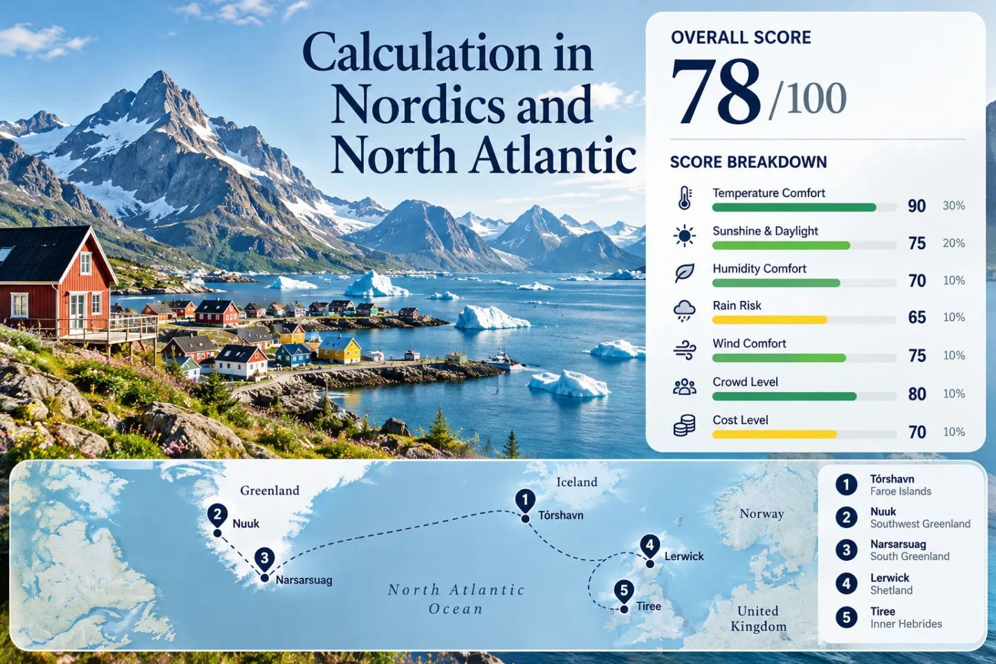
A Cooler Summer Across the Nordics and North Atlantic
The North Atlantic edge of the Nordic region offers a very different peak-summer temperature profile from continental European city breaks. Tórshavn, Nuuk, Narsarsuaq, Lerwick and Tiree combine maritime exposure, high latitude, fjords or open-ocean air with July–August daytime normals that remain modest. The trade-off is equally clear: cooler afternoons often arrive with wind, fog, rain, long transport chains or limited island capacity, so temperature alone does not determine whether a route works well.
Tórshavn, Nuuk, Narsarsuaq, Lerwick and Tiree form the common map, climate and access comparison set.
Median of the five route-level mean daily maximum values from official 1991–2020 station normals.
The route median favors cool sleeping conditions, although Greenland nights can be considerably colder.
Open Atlantic water, Arctic influence and high latitude matter more across the set than high accommodation elevation.
Greenland has no roads linking its towns, so Nuuk and Narsarsuaq require a different planning rhythm from the Scottish and Faroese bases.
From Tórshavn to Tiree: Five Cool-Air Bases
The route set follows a maritime arc from the Faroe Islands through Greenland to Shetland and the Inner Hebrides. It favors inhabited bases where official climate records and practical visitor access can be compared without treating remote weather stations as travel destinations.
This marker map is built for planning orientation. Marker positions use approximate public location centers where exact viewpoints, trailheads, legal parking areas or pull-offs are not specified. Use each route card for Google Maps links and access notes before traveling.
Nordic and North Atlantic Cooler Escape Suitability Score
This is a transparent editorial suitability index based on disclosed climate, landscape, access and pressure factors. It is not an official climate classification or a weather forecast. The score covers only the five named planning bases rather than the Nordic region as a whole.
Weighted total: 100×0.25 + 94×0.20 + 60×0.15 + 75×0.15 + 100×0.10 + 40×0.10 + 60×0.05 = 81.1 → 81/100
Method: Route count does not add bonus points. Route-level values are combined using the median before the fixed weights are applied. Climate inputs use direct official stations; the lower comparability grade reflects mixed historical periods in the heat-threshold fallback and categorical access and pressure evidence.
Fjord Towns, Atlantic Islands and Wind-Exposed Bases
None of the five bases depends on a single mountain resort or artificial high-elevation escape. The temperature advantage is mainly geographical: cold or cool surrounding water, high latitude and persistent maritime airflow. Each route has a different cost in rain, fog, cold nights or transport complexity.
Tórshavn and the Faroese Atlantic Slopes
Tórshavn is the most moderate transition point in the set. DMI's 1991–2020 normals give a July–August mean daily maximum of about 13.1°C and a mean minimum of about 9.2°C. The official station sits at 54 m, while the islands rise to nearly 890 m, allowing a visitor to move rapidly from a low coastal base into steep terrain without relying on alpine infrastructure.
DMI links the cool summer climate to the North Atlantic setting and records frequent fog in June, July and August. That makes the Faroes useful for avoiding high daytime heat, but visibility can change faster than temperature.
Nuuk and the Southwest Greenland Fjord Edge
Cool days are the defining number. DMI station 4250 records July and August mean maximum temperatures of 10.5°C and 9.7°C, giving a two-month value of about 10.1°C. Mean minimums average only about 4.3°C across the same months. The station elevation is 80 m.
The fjord-and-mountain setting creates a strong heat-avoidance case, but it also changes packing needs. A day that looks mild by continental standards can become cold when wind, cloud and boat exposure are added.
Narsarsuaq Between Fjord, Valley and Ice
Narsarsuaq is warmer by Greenland standards without becoming a warm-summer route in the usual European sense. DMI station 4270 has July and August mean daily maxima of 15.7°C and 14.1°C, or 14.9°C across the target window. Mean minimums average about 6.3°C.
The settlement sits near the head of Tunulliarfik Fjord. Visit Greenland notes that the ice sheet is roughly 6 km away and that most visitor services operate during June–September. Local movement is mainly on foot, by boat or by helicopter rather than through a conventional regional road network.
Lerwick Under Shetland's Maritime Air
The Met Office 1991–2020 normal gives Lerwick a July mean maximum of 14.40°C and an August value of 14.70°C. The corresponding minimums are 10.09°C and 10.47°C, producing two-month values of about 14.6°C by day and 10.3°C by night.
Rain remains part of the equation: the station averages about 12.1 days with at least 1 mm of rain in July and 13.1 in August. Mean wind speed is around 11 knots in both months. Those numbers describe a route where low heat does not mean settled weather.
Tiree and the Low Hebridean Atlantic Edge
Tiree is the warmest route in this selected set, yet its 1991–2020 July–August mean daily maximum is still only about 16.4°C. Mean minimums average 11.4°C. The island's low relief removes the mountain-cooling option available elsewhere, leaving open-ocean exposure as the dominant summer mechanism.
July averages 14.33 days with at least 1 mm of rain and August 15.44. CalMac's 2026 summer timetable for the Oban–Coll–Tiree route runs from late March into October, with bookings built into the ferry system.
Faroe Fog, Greenland Fjords and Scottish Island Wind
Fog Can Be the Faroese Price of Cool Air
DMI identifies frequent June–August fog as a feature of the Faroese maritime climate, with humid air cooled over surrounding sea water. The practical effect is unusual: a 13°C afternoon may solve a heat problem while creating a visibility problem on exposed roads and mountain walks.
Nuuk and Narsarsuaq Do Not Share the Same Summer
Nuuk's July–August daytime normal is roughly 4.8°C lower than Narsarsuaq's. South Greenland therefore offers a wider hiking temperature range, while Nuuk provides the stronger low-heat signal. The choice is not simply “Greenland”; the coastal sector matters.
Lerwick and Tiree Trade Heat for Exposure
Met Office normals show regular summer wind and frequent measurable rain at both stations. Tiree runs a little warmer than Lerwick, while both retain strong maritime moderation. A waterproof outer layer can matter more than searching for another few degrees of cooling.
Greenland's No-Road Network Changes the Meaning of Access
Nuuk and Narsarsuaq cannot be treated like two stops on a Nordic road trip. Official Greenland visitor transport information states that, apart from a few local exceptions, there are no roads between Greenland's towns and communities. Aircraft, helicopters and passenger boats perform the role that intercity roads and railways fill elsewhere.
Nuuk Works Better as a Base
Nuuk has the stronger urban-service profile of the two Greenland routes. The practical plan is to arrive by air, use the city as a base and treat fjord travel as a separate excursion. Trying to combine several Greenland towns in a short itinerary adds weather-sensitive flight or boat sectors very quickly.
Narsarsuaq Is More Seasonal
Visit Greenland describes June–September as the main period for hiking, sailing, kayaking, fishing and cycling around Narsarsuaq. The settlement itself is small enough for walking, while excursions depend on boats, helicopters or foot routes. A missed connection therefore has more consequences than a delayed bus on a road-linked island.
Ferry Schedules Shape Lerwick and Tiree
Lerwick and Tiree are geographically easier to understand than Greenland but remain schedule-driven islands. NorthLink's 2026 timetable provides regular Aberdeen–Lerwick sailings, while its availability tool separately tracks cabins and vehicle-deck space. A traveler bringing a car therefore has a different capacity risk from a foot passenger.
Tiree uses the CalMac Oban–Coll–Tiree corridor. The published 2026 summer service covers March 27 to October 18, with bookings available through the operator. Weather and operational changes still matter. For both Scottish routes, a cooler forecast is useful only when the ferry sector also works with the rest of the itinerary.
Five Bases Compared by Heat, Nights and Access
The same five destinations used for the marker map and suitability score are retained here. Temperature values are July–August averages calculated from the cited 1991–2020 monthly normals.
| Base | July–August Mean Max | July–August Mean Min | Primary Access Pattern | High-Ground Option | Main Summer Trade-Off |
|---|---|---|---|---|---|
| Tórshavn | 13.1°C | 9.2°C | Air + scheduled airport bus; inter-island road/ferry network | Strong local relief, below alpine elevations | Fog, wind and rapid visibility changes |
| Nuuk | 10.1°C | 4.3°C | Air + local transport + fjord boats | Mountain terrain close to the coastal base | Cold nights and no inter-town road network |
| Narsarsuaq | 14.9°C | 6.3°C | Air, helicopter and boat | Mountain, glacier and ice-sheet approaches | Seasonal services and connection sensitivity |
| Lerwick | 14.6°C | 10.3°C | Air or overnight ferry + buses | Limited elevation compared with mainland Highlands | Wind, rain and ferry cabin/vehicle capacity |
| Tiree | 16.4°C | 11.4°C | Ferry or air + limited local transport | Minimal | Wind, frequent rain days and ferry dependence |
What to Check Before a North Atlantic Booking
Temperature Is Only One Forecast Line
Check wind, low cloud and precipitation alongside maximum temperature. This matters especially in the Faroes and on exposed Scottish islands, where a mild day can still disrupt hiking, flights or ferries.
Recheck the Transport Sector
Use the operating carrier's timetable and service-status page shortly before travel. Greenland air and boat sectors, NorthLink sailings and CalMac services are all more consequential than an ordinary urban transfer.
Pack for the Night Number
Nuuk and Narsarsuaq have much colder summer-night normals than Lerwick or Tiree. A low-heat destination can require warmer evening clothing than the daytime headline suggests.