The Baltic States for a Cooler Summer
Estonia, Latvia and Lithuania offer a summer pattern built more on Baltic Sea air, forest cover, lakes and cool nights than on altitude. Coastal islands, dune peninsulas and wooded inland uplands can keep July and August milder than many continental European city breaks, although short hot spells still occur and rain becomes a larger trade-off toward late summer.
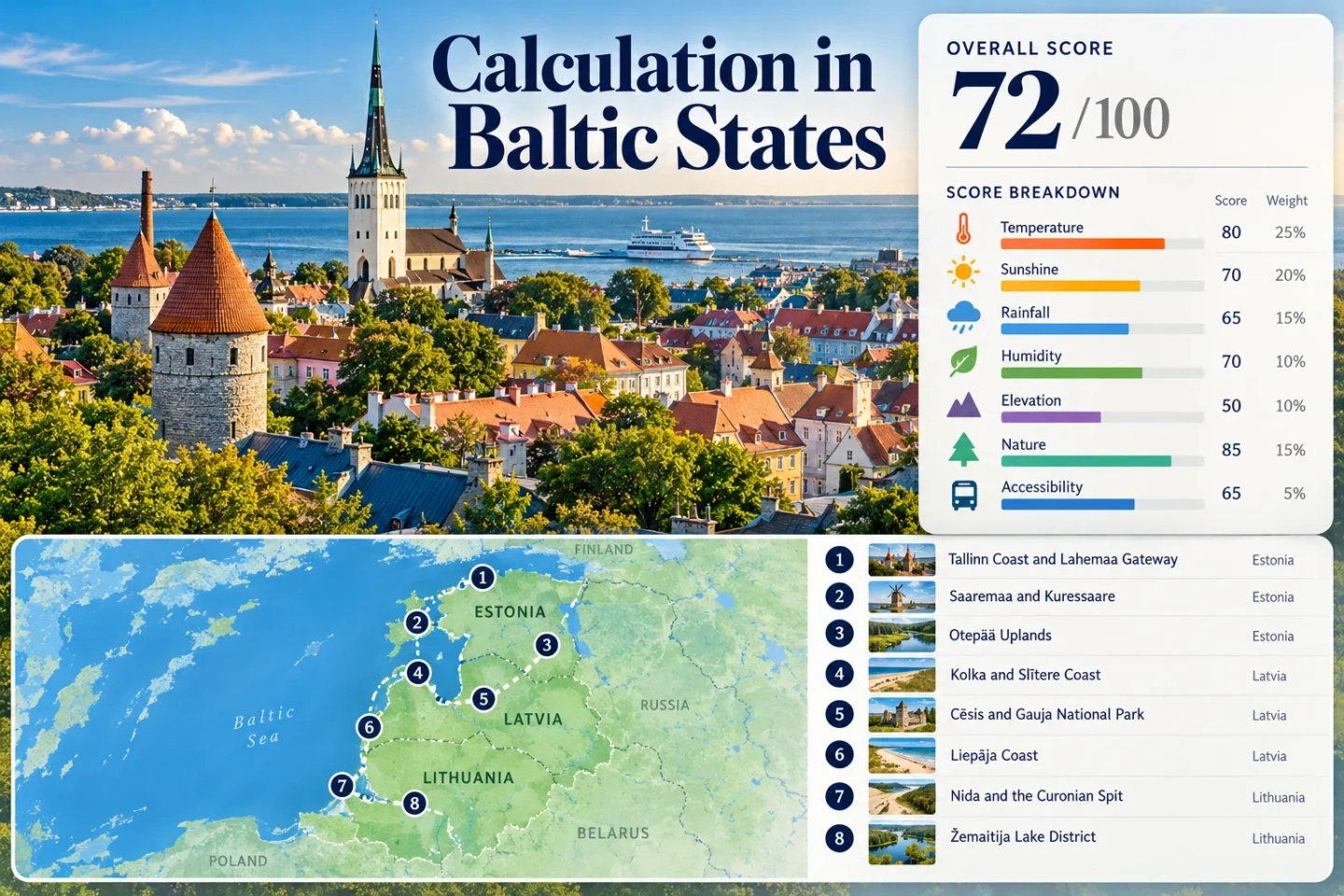
The set spans Estonia’s north coast and islands, Latvia’s western coast and Gauja Valley, and Lithuania’s Curonian Spit and Žemaitija lake country.
Vilsandi’s 1991–2020 July–August average maximum, used as the maritime proxy for Saaremaa, is the lowest two-month value in the comparable station set.
The eight route climate mappings produce a July–August median minimum near 12.6°C, supporting strong overnight cooling across most of the set.
Otepää, Cēsis and Žemaitija add rolling upland terrain, but the route portfolio does not meet the site score’s mountain thresholds at its median.
Every selected base reaches sea, lagoon, lake, river valley or substantial forest quickly; this is the Baltic region’s strongest physical cooling advantage.
These bases have the simplest direct public-transport logic. Saaremaa and Nida remain possible without a car, but ferry and transfer stages lower their access score.
From Tallinn Bay to the Curonian Spit
The route set follows the cooling systems that matter most here: open coast, wooded islands, river valleys, lake districts and modest uplands rather than true mountain terrain.
This marker map is built for planning orientation. Marker positions use approximate public location centers where exact viewpoints, trailheads, legal parking areas or pull-offs are not specified. Markers show selected cooler-route regions and planning centers, not guaranteed legal parking, trailheads or exact viewpoints.
Baltic Cooler Escape Suitability Score
This transparent editorial suitability index uses disclosed climate, landscape, access and pressure factors. It is not an official climate classification or a weather forecast. Cross-country climate tables are not perfectly uniform, so the comparability grade is C and the heatwave factor uses a conservative regional proxy rather than an invented route-level daily series.
Weighted total: 93×0.25 + 100×0.20 + 0×0.15 + 100×0.15 + 69×0.10 + 70×0.10 + 60×0.05 = 75.2 → 75/100
Method: Route count does not add bonus points. Route-level values are combined using the median before the fixed weights are applied. The heatwave proxy is intentionally conservative and lowers comparability quality rather than presenting unsupported precision.
Islands, Forest Valleys and Baltic Sea Bases
The strongest choices are not interchangeable. Some reduce daytime heat through open-water exposure, some provide cooler nights in wooded uplands, and some trade lower heat for rain, ferry stages or stronger July–August booking pressure.
Tallinn Coast and Lahemaa Gateway
Tallinn is the easiest urban base in the set for travelers who want services without giving up sea air. Tallinn-Harku’s 1991–2020 normals average about 21.6°C for the July–August daily maximum and 12.7°C for the minimum. Pirita’s shore and pine belts create quick water-and-shade options, while longer day trips can reach the forested north coast.
Main caution: Central Tallinn can feel warmer than the coastal station signal during calm hot spells, so a seaside district is a more temperature-focused base than a dense old-town street.
Saaremaa and Kuressaare
Maritime exposure is the reason to choose Saaremaa. Vilsandi, used as the island-coast climate representative, has a July–August average maximum near 20.7°C. Its average minimum is about 15.35°C, warmer at night than inland Estonia but still well below typical hot-city nights farther south in Europe.
The island mixes open coast, forest and low-density roads. Kuressaare works as the practical service base, while western and northern shores add stronger wind exposure. Access is the trade-off: the Virtsu–Kuivastu crossing inserts a ferry stage, and vehicle space can matter on summer travel days.
Otepää Uplands
Otepää is the inland counterpoint to the coast. The protected landscape mostly sits around 100–175 m and reaches 218 m at Kuutsemägi, so it is rolling upland rather than mountain country. Lake Pühajärv, forest and broken terrain still produce useful shade and evening relief.
Public buses reach Otepää, and local bus stops serve the nature-park area. A car gives more freedom for scattered lakes and trailheads, but the town itself does not require one for a short stay.
Kolka and Slītere Coast
Kolka sits where the Gulf of Riga meets the open Baltic, with dune coast, pine forest, wetlands and the Slītere landscape packed into a narrow northern Kurzeme corridor. Latvia’s July normals record only three days above 25°C at Kolka on average, while its August average maximum is 20.7°C.
The cooling case is strong; the transport case is weaker. Bus access exists, but service is thinner than on the Riga–Cēsis or Riga–Liepāja corridors. Staying several nights works better than treating Kolka as a fast in-and-out day trip.
Cēsis and Gauja National Park
Cēsis shifts the cooling mechanism from sea breeze to forest, river valley and cooler inland nights. Gauja National Park covers more than 91,000 ha and places long forest sections, ravines and river access around a compact historic town. Priekuļi’s station mean temperature is 17.7°C in July and 16.7°C in August, useful local context even though the score uses Latvia’s national max/min fallback for cross-route consistency.
The direct rail and coach logic from Riga is a major advantage for a car-light itinerary. Trail access can still require local buses, taxis or longer walks once the trip moves away from Cēsis itself.
Liepāja Coast
Liepāja is a western Baltic city base where open coast, wind exposure and urban services line up well. The station’s mean temperature normal is 17.9°C in July and 17.7°C in August. Latvia’s July climate summary also gives Liepāja about 309 sunshine hours, so a lower-heat plan here does not automatically mean grey weather.
Direct intercity transport makes it easier than Kolka, while the beach and Liepāja Lake give two distinct water systems close to the city. Wind can improve daytime comfort, but exposed beach conditions can also turn cool quickly after a front.
Nida and the Curonian Spit
Nida has the warmest nights in the selected climate set but a very stable daytime normal: the 1991–2020 average maximum is 22.2°C in both July and August, while average minima are 16.2°C and 16.3°C. The route is squeezed between the Baltic Sea and Curonian Lagoon, with pine forest and dunes limiting the amount of built-up inland heat.
Summer access carries friction. The Lithuanian side normally involves the Klaipėda–Smiltynė ferry before continuing down the spit, and Neringa applies seasonal parking charges from June 1 through August 31. That transport funnel is why Nida scores poorly on the access and pressure factors despite strong coastal cooling.
Plateliai and Žemaitija National Park
Plateliai provides a lake-and-forest alternative when Baltic beaches are windy or crowded. Telšiai is the representative station for the Žemaitija upland sector: its average maximum is 22.9°C in July and 22.1°C in August, while minima are 13.6°C and 13.0°C.
Rain is the main exchange. Telšiai averages 84 mm in July and 83 mm in August, but the route also gains dense forest shade and a large lake system. From Plungė, buses serve Plateliai; a car remains useful for spreading time across park roads, lake shores and smaller trailheads.
Sea Air Beats Elevation in the Baltic States
The Baltic States are a poor match for travelers who define a coolcation as a high-mountain stay. Otepää’s protected upland is mostly 100–175 m, while the selected Latvian and Lithuanian inland bases also stay far below alpine elevations. The score therefore gives the route set a median of zero for mountain access.
Maritime Cooling
Saaremaa, Kolka, Liepāja and Nida place the sea directly into the daily plan. Vilsandi’s two-month average maximum of 20.7°C and Kolka’s 20.7°C August maximum show why the exposed west and north coasts deserve priority during peak summer.
Forest and Lake Cooling
Otepää and Plateliai cannot compete on elevation, but they can shift activity into wooded lake country. Cēsis adds steep river-valley slopes and broad forest cover around the Gauja, creating shade and cooler evening air without a mountain transfer.
Saaremaa and Nida Add Ferry Friction
Two of the most maritime routes have the least direct transport logic. Saaremaa is reached from mainland Estonia through the Virtsu–Kuivastu ferry corridor for the standard road approach to Kuressaare. Nida on the Lithuanian side normally uses the Klaipėda–Smiltynė ferry before the road continues south along the Curonian Spit.
Saaremaa Ferry Timing
The crossing itself is short, but the practical issue is synchronization: bus, car, ferry and island-road stages become one chain. A multi-night island stay absorbs that friction better than a single-night stop, especially on summer weekends.
Nida Summer Controls
Neringa’s summer parking system operates through June, July and August, with designated zones and real-time occupancy information at several Nida lots. The Curonian Spit therefore rewards travelers who arrive by bus after the ferry or park once and use walking and cycling locally.
Latvia’s August Rain Changes the Coastal Equation
Latvia’s climate portal identifies August as its wettest month, with about 10 days reaching at least 1 mm of precipitation on average. That matters because a lower maximum temperature does not always mean a drier outdoor day. Kolka gains the coolest August daytime normal in the Latvian set, but exposed coast and showers can make the same day feel much colder than the thermometer suggests.
Kolka: Lowest Heat, More Exposure
The 20.7°C August average maximum is compelling for heat avoidance. Open shore, wind and quick weather changes make a light waterproof layer more useful here than a heavy urban summer wardrobe.
Cēsis: Forest Shade, Wet Trails
Priekuļi’s long-term precipitation is roughly 85 mm in both July and August. Forest shade remains valuable on warm afternoons, while valley trails can stay damp after rain.
Liepāja: Wind With City Backups
Liepāja combines coastal exposure with indoor city services, making weather pivots easier than at Kolka. It is the more forgiving Latvian coast base when the forecast alternates between sun, showers and stronger wind.
Eight Routes by Heat, Night Cooling and Access
The climate column uses the same values or disclosed proxies used in the score. Access describes the practical summer trip rather than straight-line distance.
| Route | Jul–Aug daytime signal | Night signal | Access pattern | Cooling assets | Main trade-off |
|---|---|---|---|---|---|
| Tallinn Coast and Lahemaa Gateway | 21.6°C direct station | 12.7°C | Direct hub; car optional | Sea, pine belts, north-coast forest | Urban heat during calm spells |
| Saaremaa and Kuressaare | 20.7°C maritime proxy | 15.35°C | Ferry plus island road | Open coast, forest | Ferry and accommodation pressure |
| Otepää Uplands | 22.45°C representative station | 12.45°C | Bus access; car expands range | Lake Pühajärv, forest, rolling terrain | No true high-mountain refuge |
| Kolka and Slītere Coast | 22.35°C score proxy; 20.7°C Aug at Kolka | 12.25°C score proxy | Longer, thinner bus corridor | Sea, dunes, pine forest, wetlands | Rain, wind and transport frequency |
| Cēsis and Gauja National Park | 22.35°C score proxy | 12.25°C score proxy | Direct rail and coach base | Forest, Gauja River, ravines | Wet trail periods |
| Liepāja Coast | 22.35°C score proxy | 12.25°C score proxy | Direct intercity base | Open Baltic coast, lake, wind | Exposed beach weather |
| Nida and the Curonian Spit | 22.2°C direct station | 16.25°C | Ferry plus spit bus or road | Sea, lagoon, dunes, pine forest | Warmest nights and peak pressure |
| Plateliai and Žemaitija National Park | 22.5°C representative station | 13.3°C | Bus from Plungė; car useful | Lake, forest, rolling upland | Frequent summer rain |
Forecast, Ferry and Trail Checks Before Departure
The region’s long-term normals support a cooler-summer strategy, but none of the eight routes is heat-proof. Check the short-range forecast before booking outdoor-heavy days, then recheck ferry timetables for Saaremaa and the Curonian Spit. After prolonged rain, forest and river-valley routes around Otepää, Gauja and Žemaitija may need a drier alternative.
Practical split: Choose Saaremaa, Kolka, Liepāja or Nida when lower daytime heat and sea exposure matter most; choose Otepää, Cēsis or Plateliai when cooler nights, forest shade and freshwater access matter more than wind. Tallinn works when easy transport and urban services carry equal weight.