Lake and Forest Summer Escapes: Shade, Water and Cooler Routes
Lake-and-forest trips can reduce summer heat exposure when water access is paired with tree cover, higher ground, northern latitude or maritime air. The strongest choices are not simply lakes with attractive shorelines. Altitude, shaded walking options, transport access and the ability to move away from exposed midday terrain determine how useful a route is during warm weather. Seven Northern Hemisphere bases show how these cooling patterns differ in July and August.
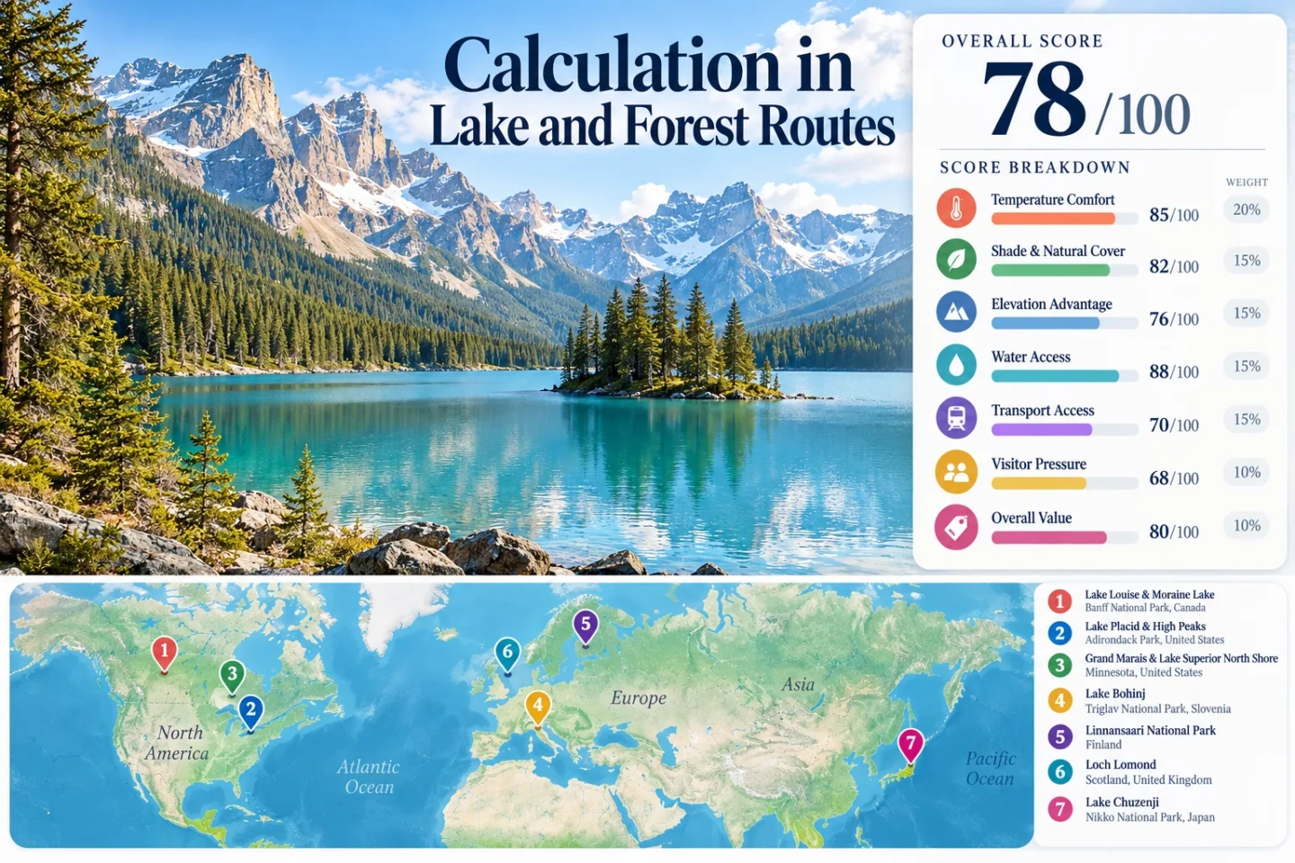
Alpine lakes, northern forest shores, island waters and high-elevation lake districts across North America, Europe and Japan.
Lake Chuzenji in Okunikko sits well above central Nikko and adds elevation to its lake-and-forest cooling pattern.
Minnesota's North Shore State Trail runs from Duluth to Grand Marais through forested country above Lake Superior.
ScotRail places the southern end of Loch Lomond about 45 minutes from Glasgow Queen Street by train.
The park's main island is reached over Lake Haukivesi, with a roughly 6 km paddle from Oravi or summer passenger-boat access.
Parks Canada shuttle seats require reservations, while Moraine Lake Road remains closed to personal vehicles year-round.
Seven Lake-and-Forest Summer Bases Across the Northern Hemisphere
The markers connect water-rich landscapes with usable shade, elevation or northern exposure. They represent planning centers rather than exact viewpoints, trailheads or legal parking locations.
Markers show selected lake-and-forest planning centers, not guaranteed legal parking, trailheads or exact viewpoints. Use the individual route links and official access information before traveling.
Water, Forest and Higher Ground Across Seven Summer Bases
Each route combines water and tree cover differently. Some rely on alpine elevation, some on large cold-water bodies, and others on northern latitude or maritime weather. Access can matter almost as much as geography when the goal is to spend less time in exposed parking areas and more time beside shaded trails or water.
Lake Louise & Moraine Lake
Banff's lake pair adds an alpine setting to dense conifer forest and cold mountain water. The practical issue is not finding water or higher ground; it is managing access during the busiest part of summer.
2026 access: Parks Canada operates Lake Louise Lakeshore shuttles from May 15 to October 12 and Moraine Lake service from June 1 to October 12, weather permitting. Reservations are required. Moraine Lake Road is closed to personal vehicles year-round.
Parks Canada Lake Louise and Moraine Lake access · Lake Louise & Moraine Lake on Google Maps
Lake Placid & High Peaks
Lake Placid works as a forest-and-water base with access to Mirror Lake, surrounding Adirondack lakes and higher terrain to the southeast. The 34-mile Adirondack Rail Trail also links Lake Placid, Saranac Lake and Tupper Lake on a shallow-grade corridor.
Village travel is easier without a car than backcountry access. Essex County operates the free Placid XPRSS within Lake Placid, while selected High Peaks trailheads can require early parking decisions, shuttle use or reservations.
New York DEC Adirondack Rail Trail information · New York DEC High Peaks access information · Lake Placid & High Peaks on Google Maps
Grand Marais & Lake Superior North Shore
Grand Marais sits beside Lake Superior with forest extending inland toward the Sawtooth highlands. The cooling character comes from the enormous lake, exposed shoreline air and the ability to shift quickly into wooded terrain.
Minnesota's 142-mile C.J. Ramstad/North Shore State Trail runs from Duluth to Grand Marais through forested ridgelines. The Gitchi-Gami State Trail adds paved segments closer to Highway 61 and the lakeshore.
Lake Superior should not be treated as a calm swimming lake by default. Minnesota DNR warns that summer water conditions can become dangerous quickly, especially for paddlers near exposed shoreline sections.
Minnesota DNR North Shore State Trail · Grand Marais & Lake Superior North Shore on Google Maps
Lake Bohinj
Lake Bohinj places a large glacial lake inside the Julian Alps, with wooded slopes and higher trails rising directly from the basin. The marked route around the lake is just over 11 km, giving walkers a long water-edge option without committing to a high mountain day.
Triglav National Park notes that the lake's surface can warm to about 24°C in summer. That makes Bohinj different from routes where the water itself stays extremely cold: swimming and shade can be part of the same day while mountain terrain remains close.
Triglav National Park Lake Bohinj route · Bohinj public transport information · Lake Bohinj on Google Maps
Loch Lomond
Loch Lomond offers a different kind of heat escape: lower elevation than alpine routes, but extensive water, wooded hills, maritime weather and unusually straightforward rail access.
Balloch is roughly 45 minutes from Glasgow Queen Street by train. Farther north, ScotRail lists approximate journeys of 1 hour 20 minutes to Arrochar & Tarbet and 1 hour 35 minutes to Ardlui. That allows travelers to choose between the more serviced southern shore and quieter northern walking country without relying entirely on a car.
Linnansaari National Park
Linnansaari shifts the route logic from driving beside a lake to moving through the lake system itself. The park lies within the Saimaa lake district and its main island is reached across Haukivesi.
The paddle from Oravi to Linnansaari is approximately 6 km; from Porosalmi it is about 12 km. Summer passenger boats operate from Oravi and Porosalmi, while taxi-boat service from Oravi operates during the open-water period from May 1 to October 31.
The main island also has forested walking, with the Linnonpolku route passing shore rock, groves and birch woodland. An accessible front-boarding boat operates from around Midsummer through the end of August.
Metsähallitus Linnansaari water access · Linnansaari National Park on Google Maps
Lake Chuzenji & Okunikko
Lake Chuzenji adds the clearest elevation contrast in the set. The lake lies at 1,269 m above sea level, has a circumference of about 25 km and sits at the entrance to Okunikko's forested uplands.
Nikko's official visitor information gives a journey of about 50 minutes by bus from JR Nikko or Tobu Nikko station to Chuzenji Onsen, followed by a short walk to the lake. Tobu's 2026 summer timetable continues the bus corridor onward toward Ryuzu Falls, Akanuma and Yumoto Onsen.
Why it stands out: Water, forest and elevation are stacked in the same corridor. A traveler can remain near the lake or continue farther into Okunikko without returning to the lower city between outings.
Nikko City Lake Chuzenji information · Tobu Bus 2026 Nikko summer timetable · Lake Chuzenji & Okunikko on Google Maps
July–August Route Decisions: Shade, Water, Access and Constraints
The useful distinction is not simply which route has a lake. The table separates the cooling mechanism from the travel friction that can determine whether the landscape is practical on a warm summer day.
| Route | Cooling Mechanism | Car-Light Viability | Water and Forest Access | Main Constraint | July–August Use |
|---|---|---|---|---|---|
| Lake Louise & Moraine Lake | Alpine elevation, cold lakes, conifer forest | Strong with reserved shuttle or Roam transit | Immediate at both lake basins | Reservations and heavy visitor pressure | High trail access; reserve transport before arrival |
| Lake Placid & High Peaks | Forest shade, lakes and nearby mountain terrain | Moderate in town; mixed for trailheads | Extensive lake and forest network | Trailhead parking and selected reservation systems | Strong for mixed cycling, lake and mountain days |
| Grand Marais & Lake Superior North Shore | Large cold-water body, shoreline air, forest ridges | Limited outside town | Continuous shoreline and inland forest options | Road dependence and rapidly changing lake conditions | Useful for shore-and-forest itineraries with flexible driving |
| Lake Bohinj | Glacial lake, wooded basin and nearby Alpine terrain | Strong with public buses and seasonal transfers | Direct lakeshore, swimming areas and mountain approaches | Summer traffic and seasonal transport changes | Strong overlap between swimming, shaded walking and hiking access |
| Loch Lomond | Maritime air, large loch and wooded hills | Strong on rail-served western and southern points | Waterfront and woodland vary by rail stop | Rain, wind and large geographic spread | Useful for travelers prioritizing low-car logistics |
| Linnansaari National Park | Northern lake district, islands and birch woodland | Mixed; mainland connection plus boat required | Water is the transport corridor as well as the landscape | Boat schedule, wind and open-water logistics | Strong for paddling and island walking when conditions cooperate |
| Lake Chuzenji & Okunikko | 1,269 m elevation, lake surface and mountain forest | Strong along the Nikko–Okunikko bus corridor | Lake, waterfalls and forest stops share one transit axis | Mountain-road traffic can slow buses | Strong option when elevation matters more than swimming |
Lake Louise, Bohinj and Chuzenji Add Height to the Water-and-Shade Formula
Water can moderate the immediate shoreline environment, but a lake does not automatically create a low-heat destination. The stronger summer combinations add either altitude or easy access to higher terrain.
Banff's Alpine Lake Basins
Lake Louise and Moraine Lake sit inside steep mountain terrain with conifer forest reaching the valley floor. The travel trade-off is capacity rather than lack of higher ground. A reserved shuttle can move a visitor directly into the alpine basin without spending the morning searching for parking.
Bohinj Supports Lake Days and Higher Trail Days
The 11 km-plus lakeshore circuit keeps a lower-effort shaded option available, while the Julian Alps rise immediately around the basin. This matters when mountain weather or physical effort makes a high trail unsuitable for an entire day.
Okunikko Starts High Before the Walk Begins
Lake Chuzenji's 1,269 m elevation removes the need to climb on foot simply to reach a high lake environment. Bus connections continuing toward Ryuzu Falls, Akanuma and Yumoto Onsen make higher forest terrain accessible along the same corridor.
Balloch Rail, Bohinj Transfers and the Okunikko Bus Change the Heat-Exposure Pattern
Transport design affects summer comfort before the walk begins. Long waits in exposed parking lots can erase much of the advantage of choosing a lake-and-forest destination. Three routes reduce that problem in different ways.
Balloch Starts at the Railway
Loch Lomond's southern end is one of the simplest transitions from a major city to a large water-and-woodland landscape. Balloch is reachable from Glasgow by rail in roughly 45 minutes, while Arrochar & Tarbet and Ardlui move the same rail strategy farther north.
Bohinj Uses Seasonal Buses to Reduce Lakeshore Traffic
Public transport reaches Ribčev Laz, and seasonal organised services connect parking areas, settlements and trail approaches around Bohinj. The exact lines change through the season, so the current timetable matters more than assuming a summer service will run unchanged into September.
Nikko's Bus Climbs Directly to the Lake
The bus from JR or Tobu Nikko station reaches Chuzenji Onsen in about 50 minutes under normal timetable conditions. It then continues deeper into Okunikko, allowing lake, waterfall and forest stops without requiring a separate vehicle for each location.
Linnansaari and Lake Superior Require Opposite Water Strategies
At Linnansaari, Water Is Part of the Transport Network
Lake Haukivesi is not merely scenery around the trail. Reaching the main island requires a passenger boat, taxi boat, canoe, rowboat or private boat. The approximately 6 km distance from Oravi is short enough for experienced paddlers to treat the crossing as part of the outing, but wind and return timing remain real constraints.
The island's birch woods and shoreline paths reward a plan built around the boat schedule rather than a fixed road itinerary.
At Lake Superior, Staying Ashore Can Be the Cooler Choice
The North Shore has long forest trails and numerous shore access points, so water exposure does not require paddling. Minnesota DNR specifically warns that apparently calm summer water can become hazardous quickly. A shaded shore hike can preserve the cooling benefit without making lake conditions part of the safety calculation.
Grand Marais therefore works well as a flexible base: shoreline when conditions are stable, wooded ridges and river corridors when the lake is rough.
Shuttle, Trail, Boat and Marine Checks Before a Summer Departure
Lake-and-forest routes still experience hot spells, thunderstorms, smoke, heavy rain, rough water and transport disruption. For Lake Louise, confirm shuttle reservations and Parks Canada alerts. In the Adirondacks, check DEC backcountry notices and any trailhead reservation requirement. Bohinj travelers should confirm seasonal bus lines; Linnansaari visitors should verify boat service and wind conditions; Lake Superior paddlers should use the current marine forecast; and Okunikko travelers should check Tobu bus times and mountain-road conditions. Current local forecasts should take priority over historical expectations when deciding whether a route will actually provide heat relief on a specific day.