El Salvador Highland Alternatives: Volcano Routes, Coffee Towns and Forest Shade
El Salvador’s cooler inland choices do not work in one uniform way. Cerro Verde and Montecristo rely on high elevation, cloud cover and dense forest; Santa Ana adds stronger summit exposure and wind; Apaneca, Concepción de Ataco, Juayúa and Los Naranjos combine mountain air with shade-grown coffee landscapes. The useful distinction is not simply how high each place sits, but whether the day is spent under canopy, on an open volcanic slope, in a service-rich town or on a wet forest road.
The same volcano, coffee-town and forest set is used in the map, score, route profiles and decision matrix.
A 1,260 m town base with coffee-covered hills, lodging and walkable services, without a protected-area entry procedure.
The cloud-forest setting offers the strongest shade continuity, but current access requires advance checks and a 4×4 vehicle.
Three easy interpretive trails create a lower-effort alternative to the exposed Santa Ana summit route.
Open summit wind, coffee-canopy shade and humid cloud forest can all reduce heat load, but they produce different rain and visibility trade-offs.
The protected-area form, current opening status and vehicle rule should be confirmed before committing to the Metapán extension.
Volcanic Spine, Coffee Ridge and Trifinio Forest
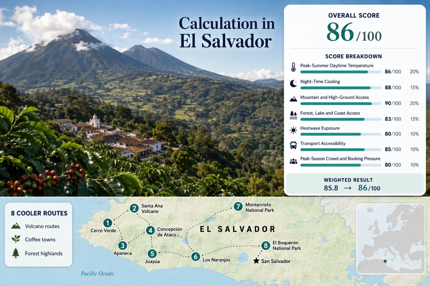
The western cluster links Cerro Verde, Santa Ana and the Ruta de las Flores, while Montecristo sits farther north near Metapán and El Boquerón provides the closest high-ground reset from San Salvador.
Markers show selected highland planning centers, not guaranteed legal parking, trailheads or exact viewpoints. Use each route card for a place-specific Google Maps search and verify current access before travel.
El Salvador Highland Cooler Escape Suitability Score
The score is a transparent editorial suitability index based on disclosed climate, landscape, access and pressure factors. It describes these eight routes rather than the whole country and is not an official climate classification or a weather forecast.
Weighted total: 95×0.25 + 100×0.20 + 100×0.15 + 75×0.15 + 60×0.10 + 70×0.10 + 50×0.05 = 85.5 → 86/100
Method: Route count adds no bonus. Every route has equal influence before the factor median is calculated. Climate-band and threshold limitations are kept visible rather than presented as direct station observations.
Volcano Bases, Coffee Towns and Cloud-Forest Roads
The route set separates easy highland bases from strenuous summit days and controlled forest access. Elevation data and climate values are planning proxies rather than same-day forecasts.
Cerro Verde Nature Park
2,030 m park base, about 37 hectares and three easy interpretive trails make Cerro Verde the lower-effort volcano option. The official high-elevation climate-band proxy is 21.6°C average maximum and 12.5°C average minimum, while thick cloud forest reduces direct solar load more reliably than the upper Santa Ana trail.
The park also functions as the organized departure point for Santa Ana and Izalco hikes. Current published departures place Santa Ana at 8:30 a.m. and Izalco at 10:30 a.m., with limited spaces.
Santa Ana Volcano
At 2,381 m, Santa Ana is El Salvador’s highest volcano. The route shares the same 21.6°C/12.5°C high-band climate proxy as Cerro Verde, but the walking experience changes once the path leaves the forest: open volcanic ground increases sun, wind and fast-changing cloud exposure.
The official environment ministry describes a 1.5–2 hour ascent and requires an authorized hiking leader. A timed start and limited capacity make this a planned full-day activity rather than an add-on to another summit.
Apaneca
Elevation: 1,477 m. The assigned official band averages 22.6°C maximum and 13.5°C minimum, placing Apaneca among the stronger overnight town bases in the western highlands. Coffee slopes, Laguna Verde and the surrounding Apaneca–Ilamatepec landscape provide a mix of shade and short nature outings.
Apaneca suits travelers who want cooler nights and a quieter base while remaining close to Ataco and the rest of the Ruta de las Flores. Rural tracks and wetland approaches can become muddy after afternoon rain.
Concepción de Ataco
Ataco sits at 1,260 m among vegetated coffee hills and uses the 22.6°C/13.5°C middle-high climate proxy. Its advantage is not the highest elevation in the portfolio; it is the combination of mountain nights, restaurants, lodging and a compact center that works without entering a national park.
Cool-air balance: Ataco is the most adaptable base for a mixed group because a low-walking day can remain in town, while coffee estates, hills and nearby Ruta de las Flores stops support longer outings.
Weekend food activity and day traffic increase pressure. A weekday overnight shifts the experience toward quieter streets and cooler evening air.
Juayúa
Juayúa occupies the lower climate band in this set, with a proxy of 28.4°C maximum and 18.1°C minimum. Its cooling value comes less from town elevation alone and more from nearby forest, waterfalls, Laguna de las Ranas and cloud-forest terrain around Portezuelo.
The town adds cafés, lodging and its weekend gastronomic fair, while the waterfall routes add steeper wet-ground demands. Shade can make a walk feel easier than an exposed volcano route even when the air temperature is higher.
Los Naranjos
Los Naranjos is a road-based coffee ridge between Santa Ana and Sonsonate rather than a single compact attraction. The 1,201–1,800 m proxy band gives 22.6°C maximum and 13.5°C minimum, while altitude and vegetation create a useful driving alternative when a summit walk is unsuitable.
Official tourism listings place restaurants and cabins around km 83.5 of CA-12S. A car offers the clearest way to compare viewpoints, cafés and lodging because the route is dispersed rather than centered on one walkable plaza.
Montecristo National Park
Montecristo rises above 2,400 m in the Trifinio border highlands. Dense cloud forest, streams and prolonged canopy make it the strongest forest-first option, while the high-band proxy of 21.6°C/12.5°C indicates markedly cooler nights than lower western towns.
Access is the limiting factor. Current MARN material states that entry is only by 4×4 vehicle; a registration form is available through the ministry, and the April 2026 schedule lists 7:30 a.m.–3:30 p.m. The wet road and controlled hours rule out a casual late start from San Salvador.
El Boquerón National Park
El Boquerón reaches roughly 1,800 m on San Salvador Volcano and offers marked trails with a short walk to crater viewpoints. The route uses the 21.6°C/12.5°C high-band proxy, although the lower road and built-up restaurant corridor can feel warmer than the forested rim.
Its practical strength is proximity to the capital area: it can replace a long western transfer when only half a day is available. The compromise is weekend road traffic and less immersion than Montecristo or Cerro Verde.
Cerro Verde Shade and Santa Ana Exposure Are Different Cooling Systems
Cerro Verde Holds the Canopy
The park’s 2,030 m base, three short interpretive trails and thick cloud forest keep much of the visit under vegetation. Mist may block the volcano and lake viewpoints, yet it can also reduce direct sun. Facilities, parking and cabins support a slower day without committing to a strenuous climb.
Santa Ana Trades Shade for Summit Air
The 2,381 m objective gains elevation but loses continuous shade on the upper route. Earlier departure matters because cloud, rain and solar exposure can all intensify later. The authorized-leader rule and fixed group timing also make the summit less flexible than the park trails below.
One Base, Two Very Different Days
Low walking load: remain in Cerro Verde. Crater objective: reserve the Santa Ana hike. Trying to treat both as interchangeable “cool volcano visits” hides the main difference: canopy comfort versus exposed ascent.
Apaneca, Ataco, Juayúa and Los Naranjos Do Not Share One Temperature Band
Why Ataco Works as the Balanced Base
Ataco does not outrank Apaneca on elevation. Its strength is operational: a 1,260 m town with lodging, food and nearby coffee landscapes allows the plan to survive rain, low energy or a group with mixed walking ability. Apaneca is higher and often quieter; Ataco is easier to use as a two-night base.
Coffee Shade Does Not Equal Lower Air Temperature
Shade-grown coffee landscapes reduce direct solar load and can make a roadside stop or short walk more comfortable. Juayúa’s assigned air-temperature band is warmer than Apaneca’s, yet a forested waterfall approach may feel easier than an exposed slope. Humidity and weak airflow can reverse that advantage.
Which Highland Route Matches the Cooling Need?
Every route in the map and score appears here. “Proxy band” refers to the official elevation-zone data used in the score, not a live local forecast.
| Route | Climate proxy | Shade continuity | Walking load | Access pattern | Main pressure |
|---|---|---|---|---|---|
| Cerro Verde Nature Park | 21.6°C max / 12.5°C min | High | Low to moderate | Road access; facilities at park | Weekend use and limited volcano-hike spaces |
| Santa Ana Volcano | 21.6°C max / 12.5°C min | Falls on upper slope | High | Timed organized ascent | Capacity, weather and volcanic-status checks |
| Apaneca | 22.6°C max / 13.5°C min | Moderate to high | Low unless adding rural trails | Established town base | Wet rural tracks after rain |
| Concepción de Ataco | 22.6°C max / 13.5°C min | Moderate | Low | Walkable town with regional road access | Weekend town and dining traffic |
| Juayúa | 28.4°C max / 18.1°C min | High on waterfall routes | Low in town; high on cascades | Established town base | Weekend fair and wet-trail risk |
| Los Naranjos | 22.6°C max / 13.5°C min | Intermittent coffee shade | Low to moderate | Dispersed CA-12S corridor; car useful | Fog, road visibility and scattered stops |
| Montecristo National Park | 21.6°C max / 12.5°C min | Very high | Moderate to high | Registration and 4×4 access | Controlled hours, road condition and closures |
| El Boquerón National Park | 21.6°C max / 12.5°C min | Moderate | Low | Closest high route to San Salvador | Weekend road and parking pressure |
July and August Change the Trails Before They Change the Calendar
Volcano Mornings Carry More Value
Santa Ana’s fixed morning departure already pushes the climb toward the more usable part of the day. Cerro Verde viewpoints can lose visibility as cloud builds, and an exposed volcanic slope offers little protection when rain begins.
Coffee Roads Gain Shade and Lose Visibility
Los Naranjos and the Apaneca–Ataco ridge can feel cooler under mist and low cloud, but the same conditions shorten sight lines on CA-12S. A slow itinerary with fewer stops is more useful than forcing every town into one wet afternoon.
Montecristo Has No Late-Start Margin
The 2026 protected-area schedule, registration step and 4×4 rule make road condition part of the route itself. Rain can turn an already controlled forest day into a cancelled or shortened plan, so an alternate western town night should remain available.
Three Live Checks Before Leaving San Salvador
Santa Ana Monitoring
Review the current MARN volcanic and weather notices before a summit day. A long-term climate proxy cannot replace same-day activity, visibility, rain or wind information.
Cerro Verde and Summit Capacity
Confirm the operating schedule, guided departure and available spaces through current ISTU or environment-ministry channels. Published times can change during maintenance or weather events.
Montecristo Entry and Vehicle Rule
Use the current MARN form and protected-area instructions, then verify that the park is open and that the arranged vehicle meets the 4×4 requirement. Do not rely on an old email address or an unverified social post.