Nicaragua Cooler Routes: Northern Highlands, Coffee Country and Cloud Forests
Northern Nicaragua changes the country’s heat pattern through elevation, cloud cover, forest shade and cooler nights. Matagalpa and Jinotega lead into wet coffee slopes and cloud forest, while Estelí and Nueva Segovia add pine ridges, open mesas and drier highland roads. The strongest heat relief sits above the main cities, so road surface, rain timing and the final mountain section matter as much as distance.
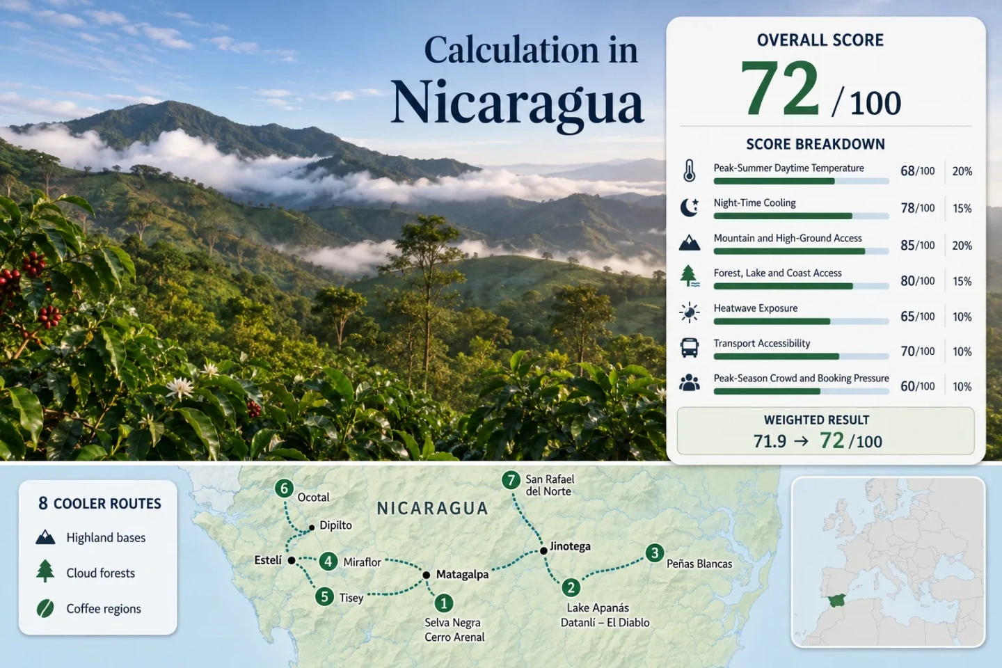
The set spans Matagalpa, Jinotega, Estelí and Nueva Segovia, with the same eight places used by the map, score and route comparison.
A high, wet massif with forest cover extending through an approximate 1,100–1,745 m elevation band.
Urban services remain close while Selva Negra and Cerro Arenal place shaded mountain terrain within a short onward journey.
Open slopes, pine cover and stronger sun create a different trade-off from the wetter Jinotega cloud-forest belt.
Cloud and elevation reduce daytime heat, but afternoon rain and unpaved last-mile roads can limit route reliability.
A short mountain approach can take longer than a paved intercity leg after heavy rain, especially near Peñas Blancas and Kilambé.
Coffee Slopes, Pine Ridges and Cloud-Forest Corridors
The markers connect four usable city bases with eight cooler-route regions. They indicate public planning centers rather than exact viewpoints, trailheads, legal parking places or private-estate entrances.
Markers show selected route regions and approximate public centers. Use the Google Maps link and access notes in each route card before travel; reserve paths and private coffee properties may begin away from the marker.
Nicaragua Northern Highland Cooler Escape Suitability Score
This transparent editorial suitability index uses disclosed temperature, landscape, access and pressure factors. It is not an official climate classification or a weather forecast. Climate values use representative municipal observations and elevation-adjusted route proxies because direct long-period stations are not published for every reserve interior.
Weighted total: 77×0.25 + 85×0.20 + 100×0.15 + 100×0.15 + 90×0.10 + 70×0.10 + 80×0.05 = 86.3 → 86/100
Method: Each route carries equal weight. Route-level values are combined by median before the seven fixed factor weights are applied. Humidity and rainfall shape planning notes but do not receive hidden score weight.
Northern Cities, Coffee Slopes and Upper Forest Roads
The city bases are not the final cooling points. Each route continues into higher, shadier or more exposed terrain, and the last road segment often decides whether the route is practical in wet weather.
Matagalpa–Selva Negra and Cerro Arenal
Cooling profile: Shaded coffee slopes and montane forest above a service-rich city base. The July–August planning proxy is about 24.8°C by day and 17.3°C at night, with upper forest terrain commonly above 1,000 m.
Matagalpa makes the route easier without flattening its climate contrast. Conditions change as the road rises toward coffee estates and Cerro Arenal, where cloud, forest cover and evening cooling become more noticeable than in the city center.
Jinotega–Lake Apanás and Datanlí–El Diablo
Jinotega links a highland city, a major reservoir and protected cloud-forest slopes in one corridor. The route proxy sits near 24.2°C for daytime highs and 18.4°C for night-time lows during July–August.
The cooling pattern is not uniform. Lake Apanás adds open water and humidity, while Datanlí–El Diablo gains denser shade and higher terrain. A lakeside stop can feel warmer than an upper reserve path on the same afternoon.
Open Jinotega–Lake Apanás and Datanlí–El Diablo in Google Maps
El Tuma–La Dalia to Peñas Blancas
Approximate elevation band: 1,100–1,745 m across the protected massif. July–August route proxy: 22.8°C daytime high and 17.5°C overnight low. Access class: Rain-sensitive rural approach.
Peñas Blancas carries the clearest wet-massif cooling profile in the portfolio. Cloud cover, continuous forest and watercourses reduce solar exposure, but the same moisture raises the chance of mud, fog and slow final access.
Estelí to Miraflor–Moropotente
Miraflor–Moropotente is not a single viewpoint. It is a broad highland landscape of settlements, farms, forest fragments and exposed ridges, so conditions vary between sheltered coffee areas and open mesa sections.
The route suits a slower stay built around one community base. Moving between widely separated sectors on the same day can erase the comfort advantage through road time.
Estelí to Tisey–La Estanzuela
The simplest Estelí day route trades deep cloud forest for open upland air, pine cover and a shorter final leg. Its July–August proxy is the warmest in the set at about 27.2°C by day, yet evenings near 18.8°C still offer relief from lower western Nicaragua.
Main caution: Open slopes can be bright and warm around midday. The route works better through elevation and wind than through continuous shade.
Ocotal–Dipilto Coffee Highlands
Base logic: Use Ocotal for transport and services, then move into Dipilto’s higher coffee and pine-oak terrain. The proxy falls from the warmer corridor toward about 25.0°C by day and 17.9°C at night in the mountain zone.
Dipilto has a clearer dry-highland character than Peñas Blancas. Tree shade can be strong within coffee properties, but open road sections receive more sun and heat can return quickly when elevation drops toward Ocotal.
San Rafael del Norte–Cerros de Yalí
San Rafael del Norte provides a quieter highland base between Jinotega’s main corridor and the forested Cerros de Yalí landscape. The route proxy is about 24.6°C by day and 18.2°C overnight.
The route is better suited to travelers who accept local transfers and fewer formal visitor facilities. Forest access, agricultural roads and settlement access should be treated as separate permissions.
El Cuá–Cerro Kilambé
Cooling profile: Remote wet forest with a proxy near 23.2°C by day and 18.0°C at night. Transport score: 40/100. Crowd score: 100/100, reflecting low visitor concentration rather than abundant visitor infrastructure.
Kilambé has one of the cooler route profiles and one of the hardest access patterns. The approach can combine a long regional journey, rural roads and a final section that should be confirmed locally after heavy rain.
Eight Routes Compared by Heat Relief and Road Friction
The same eight routes used by the map and score are compared by daytime and night-time proxy, cooling mechanism and the part of the journey most likely to fail after rain.
| Route | July–August Proxy | Main Cooling Mechanism | Last-Mile Pattern | Rain Sensitivity | Useful Rhythm |
|---|---|---|---|---|---|
| Matagalpa–Selva Negra and Cerro Arenal | 24.8°C / 17.3°C | Coffee shade, montane forest, elevation | Short onward road from Matagalpa | Moderate | One or two nights |
| Jinotega–Lake Apanás and Datanlí–El Diablo | 24.2°C / 18.4°C | Highland basin, reservoir, cloud forest | City base plus reserve transfer | Moderate to high | Early start with one city night |
| El Tuma–La Dalia to Peñas Blancas | 22.8°C / 17.5°C | Wet massif, dense canopy, cloud cover | Long rural approach | Very high | Planned overnight stay |
| Estelí to Miraflor–Moropotente | 25.2°C / 17.8°C | High mesa, forest fragments, wind | Variable roads between communities | High by sector | Single community base |
| Estelí to Tisey–La Estanzuela | 27.2°C / 18.8°C | Open elevation, pine shade, breeze | Shorter city-to-upland leg | Moderate | Morning-to-evening day trip |
| Ocotal–Dipilto Coffee Highlands | 25.0°C / 17.9°C | Coffee shade, pine-oak ridges, altitude | Paved corridor plus local mountain roads | Moderate | One night above Ocotal |
| San Rafael del Norte–Cerros de Yalí | 24.6°C / 18.2°C | Forest–farm mosaic and highland nights | Regional bus plus rural transfer | High | Flexible two-night stay |
| El Cuá–Cerro Kilambé | 23.2°C / 18.0°C | Remote wet forest and upper slopes | Long, difficult final approach | Very high | Confirmed transport and spare day |
Cloud Forest, Pine Ridge and Open Mesa Cooling
Northern Nicaragua does not produce one uniform highland climate. Three terrain systems create different forms of heat relief and different limits.
Matagalpa–Jinotega Cloud Belt
Selva Negra, Datanlí–El Diablo, Peñas Blancas, Yalí and Kilambé gain shade from dense vegetation and frequent cloud. Daytime solar load falls, but humidity, fog and wet footwear become part of the comfort equation.
Estelí’s Open Uplands
Miraflor and Tisey mix forest with exposed mesa and ridge terrain. Midday sun can be stronger than in cloud forest, while wind and faster evening cooling improve conditions after late afternoon.
Dipilto’s Pine-and-Coffee Slopes
Nueva Segovia combines pine-oak cover, coffee shade and drier road conditions than the wettest massifs. The benefit weakens quickly on descents toward Ocotal, where daytime heat is more pronounced.
Canícula Does Not Guarantee Dry Mountain Roads
July and August sit inside Nicaragua’s rainy season. A mid-season reduction in rainfall can improve some western and open-upland days, yet it does not turn Peñas Blancas, Datanlí or Kilambé into dry-season routes. Local downpours can continue on windward mountain slopes even when Estelí or the Pacific side receives a quieter spell.
Use the Morning for the Final Climb
Reserve approaches are easier to read in daylight, and morning travel reduces the chance of meeting the strongest rain on an unpaved final section.
Check the Previous 48 Hours
Road condition often reflects recent rainfall more than the weather at departure. A clear morning does not repair a saturated track or a damaged crossing.
Keep a Spare Day for the Wet Massifs
Peñas Blancas and Kilambé merit schedule slack. Forcing a same-day return can turn a cooler stay into a long road calculation.
Coffee Slopes, Reserve Boundaries and Permission
Why Coffee Slopes Can Run Cooler
Elevation, shade trees, moist soil and reduced direct sun can lower the heat load within a coffee landscape. The effect is strongest where canopy remains continuous and the route stays above the warmer valley floor.
A newly cleared or exposed plantation road may feel warmer than a nearby forest path despite having a similar elevation.
A Coffee Road Is Not Automatically Public
Selva Negra, Dipilto and parts of the Matagalpa–Jinotega coffee belt include working properties. Lodging access, farm-tour access, reserve access and through-road access can follow different rules.
Plan around an agreed entrance and activity. Do not assume that a map label grants walking access across production land.
Choose the Base by Road Tolerance, Not Only Temperature
Matagalpa
Use for: Selva Negra, Cerro Arenal and the western approach toward Peñas Blancas.
It gives the broadest service base and the easiest first highland route, with less dependence on remote lodging.
Jinotega
Use for: Lake Apanás, Datanlí–El Diablo, San Rafael del Norte and the Yalí corridor.
It suits mixed lake-and-forest planning, though the route must still separate city, reservoir and reserve conditions.
Estelí
Use for: Miraflor–Moropotente and Tisey–La Estanzuela.
It offers the strongest choice between a community-based highland stay and a simpler upland day trip.
Ocotal
Use for: Dipilto and the Nueva Segovia mountain corridor.
Stay higher in Dipilto for night cooling; returning to Ocotal reduces the temperature advantage.
What to Confirm Before Leaving the Paved Corridor
Access and Timing
Confirm the final road, bridge condition, entry hour, gate location, escort requirement and expected return before starting the rural section.
Vehicle and Daylight
Match the vehicle to the latest road report, carry a daylight margin and avoid relying on a night arrival for Peñas Blancas or Kilambé.
Wet-Cool Layers
Use quick-drying clothing, a light waterproof shell, footwear suited to mud and a dry bag for electronics. Wet clothing can make an 18°C evening feel much colder.