Dominican Republic Mountain Escapes: Cordillera Towns, Pine Forests and High Valleys
The Dominican Republic’s summer cooling pattern is vertical rather than coastal: Jarabacoa offers an accessible river-valley base, Constanza adds stronger night cooling near 1,200 metres, and the roads into Valle Nuevo rise above 2,200 metres into pine forest, cloud, wind and markedly cooler afternoons. The trade-off is equally clear. Every gain in elevation brings more dependence on road surface, local transport, park access and fast-changing mountain weather.
Two town bases, protected forests, high park roads and trekking valleys; route count does not raise the score.
The national heat season is at full strength, making elevation and night cooling more useful decision measures than annual averages.
A serviceable high-valley base with a published July–August profile near 26°C by day and 16°C overnight.
Valle Nuevo and Las Pirámides move the route from cultivated valley floor into exposed pine-plateau conditions.
Intercity coach access reaches town; waterfalls, park gateways and remote valleys still require local transfers.
A cool forecast does not guarantee a workable high-road day after heavy rain or reduced mountain visibility.
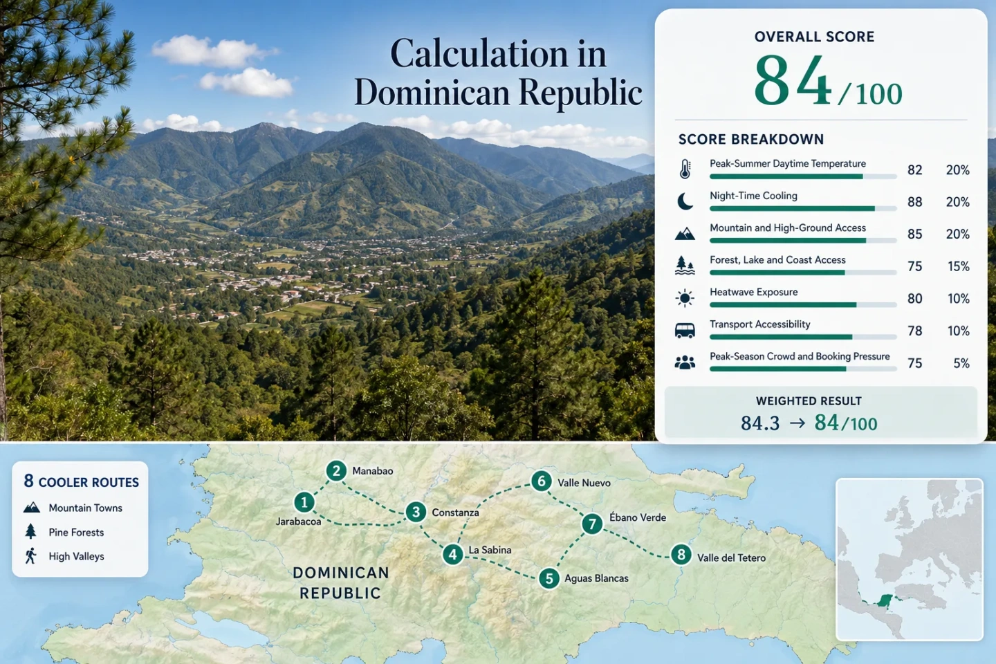
From Jarabacoa’s River Valley to Valle Nuevo’s High Plateau
The eight markers follow the same route set used in the score, route profiles and comparison matrix. They show planning centres rather than guaranteed trailheads, legal parking points or exact viewpoints.
This marker map is built for planning orientation. Marker positions use approximate public location centres where exact viewpoints, trailheads, legal parking areas or pull-offs are not specified. Use each route profile for Google Maps searches and access notes before travelling.
Dominican Cordillera Cooler Escape Suitability Score
A transparent editorial suitability index based on disclosed climate, landscape, access and pressure factors. It is not an official climate classification or a weather forecast. Each route carries equal weight; the portfolio value for every factor is the median of the same eight routes.
Method: Representative published July–August daily-high profiles for Jarabacoa and Constanza, combined with elevation-adjusted route proxies for nearby high roads, protected forests and trekking valleys. The 25.0°C route median maps to 75/100 under the fixed temperature scale.
Raw: Median average daily maximum, 25.0°C.
Route values: Jarabacoa and the Baiguate–Jimenoa Valley 30.0°C; Manabao–La Ciénaga Gateway 26.0°C; Constanza Central Valley 26.0°C; La Sabina–Colonia Japonesa Upland Loop 25.0°C; Salto de Aguas Blancas High-Forest Road 22.0°C; Valle Nuevo: La Siberia–Las Pirámides 22.0°C; Casabito–Ébano Verde Cloud-Forest Pass 24.0°C; Valle del Tetero High-Valley Expedition 25.0°C. Sorted middle values: 25.0°C and 25.0°C.
Source mapping: Jarabacoa and Constanza use direct published place profiles. Manabao uses a published August local profile. The remaining routes are proxy values anchored to the nearest town profile, official elevation band and documented high-forest setting; no station code is published for those route centres.
Period: July–August planning baseline, reviewed July 30, 2026.
Sources: WeatherSpark Jarabacoa climate profile; WeatherSpark Constanza climate profile; AccuWeather Manabao August profile; Dominican Republic tourism — Valle Nuevo.
Method: Representative July–August overnight minima use the same town profiles and elevation-proxy mapping as the daytime factor. A 15.0°C median falls inside the fixed 10–16°C full-score band.
Raw: Median average daily minimum, 15.0°C.
Route values: Jarabacoa and the Baiguate–Jimenoa Valley 20.0°C; Manabao–La Ciénaga Gateway 15.0°C; Constanza Central Valley 16.0°C; La Sabina–Colonia Japonesa Upland Loop 16.0°C; Salto de Aguas Blancas High-Forest Road 14.0°C; Valle Nuevo: La Siberia–Las Pirámides 14.0°C; Casabito–Ébano Verde Cloud-Forest Pass 15.0°C; Valle del Tetero High-Valley Expedition 15.0°C. Sorted middle values: 15.0°C and 15.0°C.
Source mapping: Direct profiles apply to Jarabacoa, Constanza and Manabao. High-route values are conservative proxies based on documented elevations rather than winter cold records; no February minimum is used as a summer-night substitute.
Period: July–August planning baseline, reviewed July 30, 2026.
Sources: WeatherSpark Jarabacoa temperature profile; WeatherSpark Constanza temperature profile; Dominican Republic tourism — Constanza; Dominican Republic tourism — Aguas Blancas.
Method: Fixed elevation-access rubric. A route scores 100 when its base is at or above 900 metres or it provides regular access to terrain above 1,500 metres within about 60 minutes. Route-level scores are combined by median.
Raw: Median categorical route score, 100/100.
Route scores: Jarabacoa and the Baiguate–Jimenoa Valley 60; Manabao–La Ciénaga Gateway 100; Constanza Central Valley 100; La Sabina–Colonia Japonesa Upland Loop 100; Salto de Aguas Blancas High-Forest Road 100; Valle Nuevo: La Siberia–Las Pirámides 100; Casabito–Ébano Verde Cloud-Forest Pass 100; Valle del Tetero High-Valley Expedition 100. Sorted middle scores: 100 and 100.
Route rationale: Jarabacoa sits lower but opens direct mountain corridors. La Ciénaga, Constanza, Ébano Verde and Valle del Tetero occupy high bases, while Aguas Blancas and Valle Nuevo reach substantially higher road-linked terrain.
Period: Access and terrain status reviewed July 30, 2026.
Sources: Dominican Republic tourism — Jarabacoa; Dominican Republic tourism — Constanza; Dominican Republic tourism — Pico Duarte access; Dominican Republic tourism — Valle del Tetero.
Method: Fixed proximity rubric using forest, large river and other cooling landscape access. Two strong elements within about 30 minutes score 100; one strong element scores 75.
Raw: Median categorical route score, 100/100.
Route scores: Jarabacoa and the Baiguate–Jimenoa Valley 100; Manabao–La Ciénaga Gateway 100; Constanza Central Valley 75; La Sabina–Colonia Japonesa Upland Loop 75; Salto de Aguas Blancas High-Forest Road 100; Valle Nuevo: La Siberia–Las Pirámides 100; Casabito–Ébano Verde Cloud-Forest Pass 100; Valle del Tetero High-Valley Expedition 100. Sorted middle scores: 100 and 100.
Route rationale: Jarabacoa and Manabao combine forested slopes with major river systems. Aguas Blancas adds a cold cascade inside pine and green-ebony terrain. Valle Nuevo, Ébano Verde and Valle del Tetero are protected forest landscapes with streams or river headwaters. Constanza’s open valley and La Sabina’s cultivated uplands receive a single-element score.
Period: Landscape access reviewed July 30, 2026.
Sources: Dominican Republic tourism — Jarabacoa rivers and waterfalls; Dominican Republic tourism — Valle Nuevo forests and headwaters; Dominican Republic tourism — Aguas Blancas; Dominican Republic tourism — Valle del Tetero.
Method: Proxy Dataset calculation using NOAA Global Summary of the Day daily maximum temperatures from Cibao International station 78460099999. Each valid July–August day was converted to Celsius and shifted by the difference between the station’s 33.69°C selected-period mean and the disclosed mean-maximum profile for each route. The adjusted daily series was then counted against the fixed 30°C threshold.
Raw: Median route exposure, 0.0% of valid July–August days at or above 30°C. The fixed scale awards 100/100 at 0–1% exposure.
Route values: Jarabacoa and the Baiguate–Jimenoa Valley 138/248 days, 55.6%; Manabao–La Ciénaga Gateway 0/248, 0.0%; Constanza Central Valley 0/248, 0.0%; La Sabina–Colonia Japonesa Upland Loop 0/248, 0.0%; Salto de Aguas Blancas High-Forest Road 0/248, 0.0%; Valle Nuevo: La Siberia–Las Pirámides 0/248, 0.0%; Casabito–Ébano Verde Cloud-Forest Pass 0/248, 0.0%; Valle del Tetero High-Valley Expedition 0/248, 0.0%. Sorted middle values: 0.0% and 0.0%.
Coverage: 248 valid daily maxima from 310 expected July–August dates in 2016–2020, equal to 80.0% coverage. The calculation is a station-anomaly proxy, not a direct highland observation; the shorter-than-preferred daily window contributes to comparability class C.
Source mapping: Cibao International lies at 172.2 metres near Santiago and supplies the daily variability signal. Route-level offsets use the same July–August profiles disclosed in the daytime-temperature factor. This preserves observed hot-day sequencing while adapting the mean to each route, but it cannot fully reproduce ridge, cloud-forest or valley-inversion microclimates.
Period: July–August 2016–2020; station files contain full target-month coverage for 2016, 2017, 2018 and 2020.
Sources: NOAA NCEI Global Summary of the Day; Cibao International daily file — 2016; Cibao International daily file — 2017; Cibao International daily file — 2018; Cibao International daily file — 2020.
Method: Fixed access rubric combining regular public transport to the usable base with the complexity of reaching the cooling terrain. A simple car or local transfer scores 60; rough-road, guided or expedition access scores lower.
Raw: Median categorical route score, 60/100.
Route scores: Jarabacoa and the Baiguate–Jimenoa Valley 100; Manabao–La Ciénaga Gateway 60; Constanza Central Valley 100; La Sabina–Colonia Japonesa Upland Loop 60; Salto de Aguas Blancas High-Forest Road 40; Valle Nuevo: La Siberia–Las Pirámides 40; Casabito–Ébano Verde Cloud-Forest Pass 60; Valle del Tetero High-Valley Expedition 20. Sorted middle scores: 60 and 60.
Route rationale: Coach and local services make Jarabacoa and Constanza workable town bases. Aguas Blancas requires an all-terrain vehicle, Valle Nuevo favours an SUV or 4x4, and Valle del Tetero depends on hiking or horseback logistics rather than ordinary road access.
Period: Transport and route-access status reviewed July 30, 2026.
Sources: Dominican Republic tourism — intercity and local transport; Dominican Republic tourism — Constanza access; Dominican Republic tourism — Aguas Blancas vehicle requirement; Dominican Republic tourism — Pico Duarte route logistics.
Method: Categorical pressure rubric used because a common eight-route occupancy series is not published. The score reflects town visitation, protected-area capacity, mountain-leader dependence and camping restrictions rather than a fabricated booking percentage.
Raw: Median categorical route score, 60/100.
Route scores: Jarabacoa and the Baiguate–Jimenoa Valley 60; Manabao–La Ciénaga Gateway 60; Constanza Central Valley 60; La Sabina–Colonia Japonesa Upland Loop 80; Salto de Aguas Blancas High-Forest Road 80; Valle Nuevo: La Siberia–Las Pirámides 40; Casabito–Ébano Verde Cloud-Forest Pass 60; Valle del Tetero High-Valley Expedition 40. Sorted middle scores: 60 and 60.
Route rationale: Jarabacoa receives higher summer visitation, while protected high routes face narrower vehicle, mountain-leader or camping capacity. Valle Nuevo’s 2026 camping transition places more planning pressure on overnight stays than on ordinary daytime entry.
Period: Current visitor and access pattern reviewed July 30, 2026.
Sources: Dominican Republic tourism — Jarabacoa visitation pattern; Dominican Republic tourism — Constanza season pattern; Environment Ministry — Jardín del Edén camping transition; Environment Ministry — Valle Nuevo public access.
River Valleys, Pine Roads and High-Country Bases
The same eight planning clusters cover three distinct trip types: town-based cooling, rough-road day trips and guided high-valley travel. A colder route is not automatically the easier or more useful choice.
Jarabacoa and the Baiguate–Jimenoa Valley
Jarabacoa provides the least complicated entry into the Cordillera Central. The town sits below the colder Constanza basin, yet it places the Baiguate and Jimenoa corridors, La Confluencia and the upper Yaque del Norte within a practical local-transfer radius. The July–August climate profile is still hot at midday, so the cooling value comes from greener surroundings, river access and more tolerable nights rather than an all-day alpine effect.
Salto de Baiguate is about 20 minutes from town in the official destination material, while Jarabacoa itself is roughly two hours from Santo Domingo and one hour from Santiago. That combination suits a short mountain stay without committing to rough high-park roads.
Manabao–La Ciénaga Gateway
Elevation changes the route quickly: La Ciénaga is used as a high gateway for the popular Pico Duarte approach, while Manabao provides a road-linked valley transition west of Jarabacoa. A representative August profile near 26°C by day and 15°C overnight is more favourable for sleeping than Jarabacoa’s lower valley.
The popular Pico Duarte sequence continues from Jarabacoa through Manabao and La Ciénaga toward Compartición and Valle de Lilís. Reaching the gateway is not the same as completing the climb: official route information describes a two- or three-day mountain excursion, with local mountain-leader and pack-animal arrangements commonly organised locally.
Constanza Central Valley
Constanza is the strongest town-based choice for sustained night cooling. Its cultivated basin offers accommodation, food and local services while keeping Valle Nuevo, Aguas Blancas and Ébano Verde within the wider trip plan. Published July and August averages sit near 26°C for daytime highs and 16°C for overnight lows, a much clearer heat reduction than Jarabacoa’s lower basin.
Official travel information places Constanza about 2.5 hours from Santiago and 3.5 hours from Santo Domingo. The town is therefore a base rather than a quick extension from the resort coast. Open fields can still feel hot under midday sun, but the evening temperature drop is the defining advantage.
La Sabina–Colonia Japonesa Upland Loop
The agricultural uplands east and southeast of central Constanza replace dense forest with open slopes, cultivated fields and broad valley views. The planning profile remains close to 25°C by day and 16°C at night, but shade is less reliable than on the Aguas Blancas or Ébano Verde routes.
High-valley elevation, morning air and rapid evening cooling.
Strong sun over open farmland can erase much of the perceived daytime advantage.
The loop is suited to a local driver, high-clearance vehicle or carefully planned cycling outing rather than a shaded walking escape at noon. It also shows why “mountain” is too broad a label: open agricultural terrain and nearby cloud forest can sit in the same district while feeling very different.
Salto de Aguas Blancas High-Forest Road
Aguas Blancas is valuable as an elevation transition, not only as a waterfall stop. The approach climbs through high forest and cultivated mountain settlements before reaching an 83-metre cascade and cold pool. Official destination information states that an all-terrain vehicle is necessary for the roughly 10-kilometre approach.
The route’s summer planning proxy of about 22°C by day and 14°C overnight reflects its high-forest setting rather than a direct on-site station normal. The cold-water warning remains relevant even when the air is mild: official material cautions against hypothermia, particularly during colder mornings and the November–March period.
Valle Nuevo: La Siberia–Las Pirámides
The strongest road-linked altitude band in the portfolio begins above 2,200 metres. Valle Nuevo covers highland plains, pine forest, cloud forest and exposed mesa terrain; Las Pirámides stands near 2,300 metres in the area known as La Nevera. Official tourism material gives a broad park temperature range of 14–22°C and describes a protected landscape of about 902 square kilometres.
Day visitors and overnight campers now require different planning. In April 2026 the Environment Ministry restated that Valle Nuevo remained open to public access and listed a general entry fee of RD$150. Camping was shifted to Jardín del Edén from April 1, 2026, with reservation details to be communicated through official channels.
Casabito–Ébano Verde Cloud-Forest Pass
Ébano Verde offers a wetter form of cooling than Valle Nuevo. Cloud, mist, dense vegetation and Arroyo Frío can reduce solar exposure, but higher humidity and wet surfaces change the comfort equation. A 24°C daytime and 15°C night proxy places it between Constanza’s open basin and Valle Nuevo’s exposed high plateau.
The protected-area category matters. A scientific reserve is not managed as an unrestricted recreation landscape, and access conditions can differ from those at a general national park. The reserve management plan was updated on April 20, 2026, so trail, entry and permitted-use details warrant a fresh local check.
Valle del Tetero High-Valley Expedition
Valle del Tetero is the route that most clearly separates a cool mountain trip from a drive-up viewpoint. The pine-covered valley lies inside José del Carmen Ramírez National Park and is associated with hiking, horseback travel, freshwater stops and camping. The nearby El Tetero summit rises just above 1,500 metres; the valley planning centre sits in a similar high-country band.
Its cooling potential is strong, but the transport score is the lowest in the portfolio because the usable experience depends on expedition logistics. Cooler does not mean simpler.
Eight Cordillera Routes Compared by Cooling and Access
The temperature column is a July–August planning profile. Direct town values and elevation proxies are kept separate in the route descriptions; none of the figures should replace a live mountain forecast.
| Route cluster | Elevation band | July–August profile | Primary access | Cooling asset | Main limit |
|---|---|---|---|---|---|
| Jarabacoa and the Baiguate–Jimenoa Valley | About 552 m | 30°C / 20°C | Coach to town; local transfers | Rivers, waterfalls and greener nights | Warm, humid afternoons |
| Manabao–La Ciénaga Gateway | Up to about 1,270 m at gateway | 26°C / 15°C | Road transfer; organised trek beyond | High nights and Pico Duarte corridor | Mountain-leader and pack-animal logistics |
| Constanza Central Valley | About 1,200 m | 26°C / 16°C | Intercity service or car | Town services plus clear night cooling | Open-field sun at midday |
| La Sabina–Colonia Japonesa Upland Loop | High-valley slopes | 25°C / 16°C proxy | Local vehicle or cycling plan | Morning air and elevated farmland | Limited shade |
| Salto de Aguas Blancas High-Forest Road | High-forest mesa | 22°C / 14°C proxy | All-terrain vehicle | Cold cascade and pine forest | Rough 10 km approach |
| Valle Nuevo: La Siberia–Las Pirámides | Above 2,200 m | 22°C / 14°C proxy | SUV or 4x4 | Exposed pine plateau and wind | Fog, road condition and camping rules |
| Casabito–Ébano Verde Cloud-Forest Pass | About 1,535 m reserve band | 24°C / 15°C proxy | Road approach plus reserve access | Cloud shade, forest and cold stream | Wet surfaces and protected-use limits |
| Valle del Tetero High-Valley Expedition | About 1,500–1,650 m | 25°C / 15°C proxy | Foot, horse and guided logistics | Pine valley and freshwater | Multi-stage access and weather exposure |
Jarabacoa and Constanza Solve Different Heat Problems
Jarabacoa Reduces Travel Friction
Jarabacoa is the stronger start when coach access, a broader accommodation base and short waterfall transfers matter more than the lowest afternoon temperature. The town’s July–August profile near 30°C and 20°C means that a shaded river corridor can feel better than the centre, but the route remains tropical and humid.
Choose it for: A two-night mountain break, mixed activity levels or a car-light arrival followed by hired local transport.
Constanza Reduces Overnight Heat
Constanza’s advantage is not only a lower daytime high. The basin’s published 16°C summer overnight profile changes sleep comfort and creates a stronger early-morning window for walking, cycling or driving toward Valle Nuevo. The cost is a longer transfer and greater dependence on a vehicle for the colder routes.
Choose it for: Three or more nights, a high-road itinerary or travellers who rank cool sleeping conditions above easy arrival.
Valle Nuevo’s 2026 Access Rules Change the Overnight Plan
Public access and camping are separate decisions. The Environment Ministry stated on April 29, 2026 that Valle Nuevo had not been privatised and that ordinary public entry continued, with a general admission fee of RD$150 at that time. The same clarification separated the entrance fee from camping charges.
Public access remained available under park controls. Entry status should still be checked after weather alerts.
Camping shifted to Jardín del Edén from April 1, 2026 rather than continuing under older site assumptions.
Official communication indicated that online booking details would be issued through ministry channels, so an old campsite post is not sufficient confirmation.
For summer planning, the practical result is straightforward: a daytime La Siberia–Las Pirámides route can remain feasible while an overnight plan still fails because the camping reservation, vehicle or weather status has not been confirmed. Do not treat public entry as automatic permission to camp anywhere in the plateau.
Road Surface Determines How Far the Cooling Continues
The most comfortable air in the portfolio often begins where ordinary transport becomes less reliable. Jarabacoa and Constanza can be reached as town bases, but the final movement into Aguas Blancas, Valle Nuevo, Pico Duarte gateways or Valle del Tetero requires a different access decision.
| Access type | Routes it suits | What it unlocks | Summer constraint |
|---|---|---|---|
| Intercity coach plus local taxi | Jarabacoa; Constanza town | Town-based night cooling and organised day transfers | Does not solve rough final approaches |
| Standard car | Jarabacoa valley; Constanza centre; some upland roads | Flexible timing and two-base travel | Road suitability can end before the coldest terrain |
| High-clearance SUV or 4x4 | Aguas Blancas; Valle Nuevo | High-forest and plateau access above the town basins | Mud, fog and washouts can still stop progress |
| Organised foot or horseback travel | La Ciénaga onward; Valle del Tetero | Remote pine valleys and multi-day high country | Fitness, mountain-leader availability, river conditions and camping logistics |
July and August Combine Cooler Altitude with Wetter Decisions
July and August sit inside the Dominican Republic’s hottest national period, but Cordillera routes do not respond uniformly. Jarabacoa can remain hot and muggy through the afternoon, Constanza usually retains a meaningful overnight advantage, and Valle Nuevo can be cool enough for layers while still receiving intense sun between cloud periods.
July: Start High-Road Days Early
Long daylight supports early departures, but exposed agricultural roads and lower valleys warm quickly. Valle Nuevo, Aguas Blancas and Ébano Verde gain from a morning start that leaves time for cloud, rain or road delays before the return.
August: Protect the Overnight Margin
Jarabacoa’s humidity remains high while Constanza and the higher valleys preserve stronger night cooling. Tropical-weather monitoring becomes more important, especially for trekking, camping and any road with limited turnaround space.
Rain Can Cool the Air and Weaken the Route
Cloud and rain may reduce afternoon heat, yet the same event can lower visibility, increase river flow, soften unpaved surfaces and make cold-water stops less suitable. Cooler weather is not automatically a safer operating window.
Pack by Elevation Band, Not by Island Expectations
Jarabacoa’s Lower Valley
Breathable clothing, rain protection, traction for wet paths and one light evening layer. Heat and humidity remain part of the day.
Constanza, La Ciénaga and Ébano Verde
Add a warmer evening layer and a waterproof outer shell. Mist, damp surfaces and a rapid temperature drop after sunset matter more than coastal packing habits suggest.
Valle Nuevo and Expedition Routes
Use an insulating mid-layer, wind and rain protection, proper hiking footwear and dry backup clothing. Camping equipment must match the confirmed overnight conditions, not the daytime temperature in Constanza.