Jamaica Beyond the Beach Heat: Blue Mountains, Coffee Roads and Highland Mornings
Kingston can begin the day warm and humid while the road through Irish Town, Newcastle and Holywell climbs into mist, forest shade and cooler air. Farther east, the Mavis Bank corridor changes from coffee country to four-wheel-drive roads and long summit approaches. The useful distinction is not simply coast versus mountain: each elevation band has a different morning rhythm, access burden and rain trade-off.
The assessed set runs from the Mavis Bank coffee base to Jamaica's highest summit.
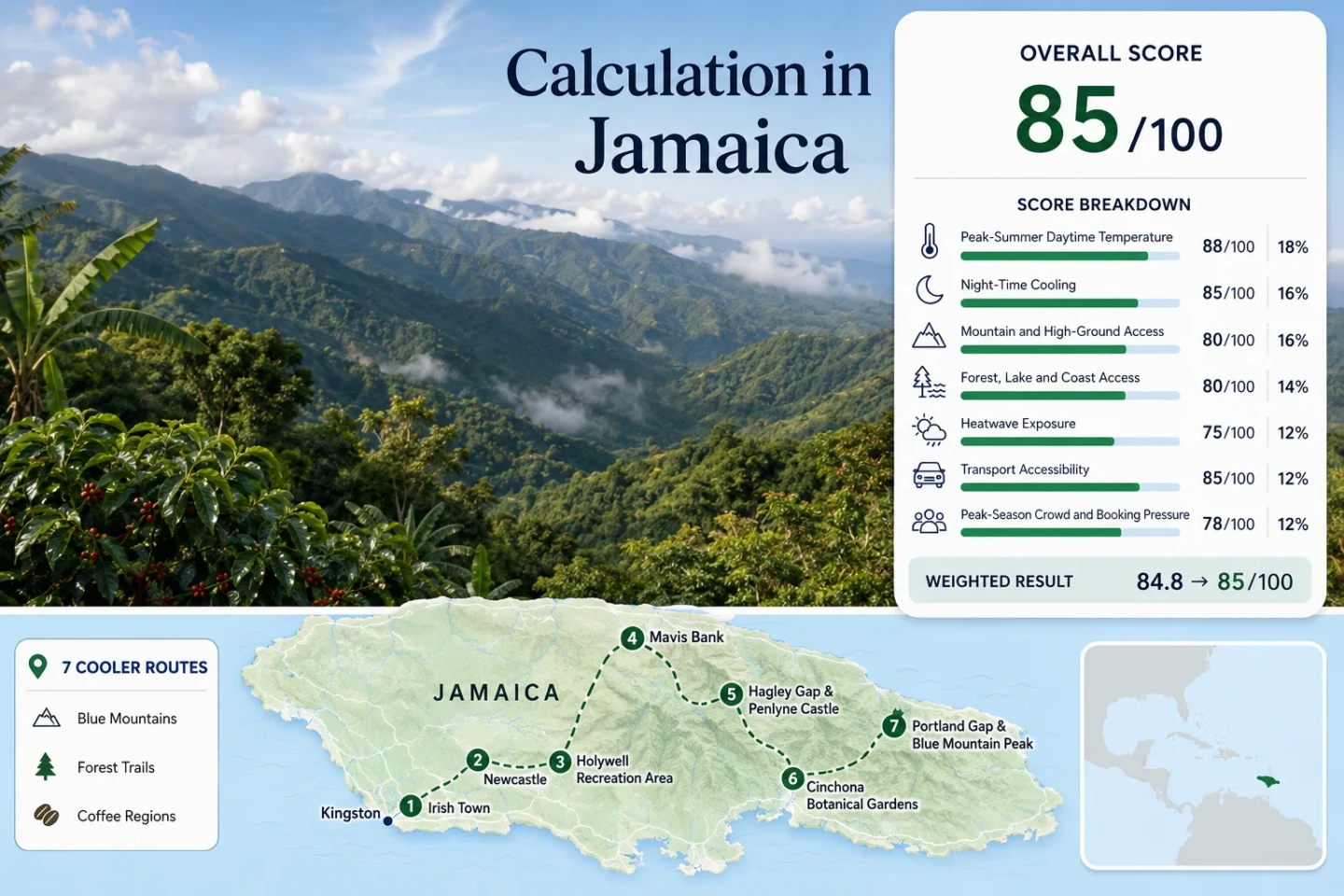
The score, marker map and route comparison use the same seven locations.
The park's published average daytime and nighttime figures are broad planning anchors, not a daily forecast.
Altitude helps define Jamaica Blue Mountain coffee, but the label also depends on regulated origin and certification.
Irish Town, Newcastle and Holywell form the clearest coffee, ridge and forest sequence from Kingston.
Fog, afternoon rain and four-wheel-drive sections become increasingly important beyond Mavis Bank and Hagley Gap.
Coffee Slopes, Forest Roads and Peak Approaches
Markers show selected highland planning centers rather than exact viewpoints, legal parking spaces or trailheads. The western sequence is the more compact Kingston outing; the eastern sequence demands progressively more road and trail coordination.
Use the Google Maps link in each route card for general orientation, then confirm current road, park and trail access locally before departure.
Jamaica Blue Mountains Cooler Escape Suitability Score
This transparent editorial suitability index uses disclosed climate, landscape, access and pressure factors. It is not an official climate classification or a weather forecast. Route-level temperature and heat-threshold values use a clearly identified highland proxy because one common official station normal is not published for all seven locations.
Weighted total: 95×0.25 + 85×0.20 + 100×0.15 + 75×0.15 + 100×0.10 + 40×0.10 + 80×0.05 = 85.0 → 85/100
Method: Each route carries equal weight within a factor. The route median is calculated first, then the seven fixed weights are applied. Route count adds no bonus.
Blue Mountain Bases from Irish Town to the Peak
A relaxed coffee morning and a pre-dawn summit ascent belong to the same mountain range but require very different planning. The route cards separate the accessible western road from the more demanding eastern approach.
Irish Town Coffee Slopes
Irish Town is the first meaningful change in air and road character above Papine. Coffee estates, hillside breakfasts and verandas make it suitable for a lower-effort morning, while the road continues toward Redlight, Newcastle and Holywell.
Good for: Travelers seeking coffee and a noticeable elevation shift without committing to a long hike. Private estate visits commonly require advance arrangement.
Newcastle Ridge and Open Mountain Air
Newcastle sits higher and more exposed than Irish Town. Wind and passing cloud can change the feel quickly, and early views toward Kingston may disappear behind mist before afternoon.
The area functions more as a ridge passage and mountain-air stop than a full visitor hub. Short stops work better than improvised roadside parking, especially when visibility falls.
Holywell Forest Mornings
Holywell is the clearest low-to-moderate effort cool-air base in the set. Five marked walks range from short nature loops to longer forest and waterfall routes, allowing the day to be scaled around weather and fitness.
The Blue Mahoe walk is only a few hundred metres, while Oatley and Waterfall routes add distance, wet ground and more sustained forest time. Cabins, campsites and guided activities make an overnight stay possible.
Mavis Bank Coffee-Country Base
Mavis Bank is the warmest route base in the assessed set, but it is strategically important: the settlement marks the shift from an ordinary mountain road to the Peak Trail access chain.
Coffee processing and cultivated slopes dominate the local landscape. The strongest cooling comes from continuing uphill rather than treating the town itself as the final highland stop.
Hagley Gap and Penlyne Castle Approach
The road from Mavis Bank reaches Hagley Gap after about 7 km, but the next stages are not a simple continuation. The official route table identifies 4 km from Hagley Gap to Penlyne Castle by four-wheel drive or on foot.
Penlyne Castle is the usual start of the 12.5 km ascent to the Peak. Coffee and vegetable farms give way to natural forest higher on the route.
Cinchona Botanical Gardens High Station
Cinchona occupies one of the highest cultivated sites in the route set. The elevation produces strong daytime relief and cooler nights, but access is the trade-off: official material advises four-wheel drive and skilled mountain driving.
The botanical setting and remoteness suit a planned, low-volume visit rather than a spontaneous detour from Kingston.
Portland Gap and Blue Mountain Peak
Portland Gap is the final rustic rest and overnight point before the Peak. The last 5.6 km usually takes about two to three hours, while the common Penlyne Castle start creates a 12.5 km ascent to the summit.
Pre-dawn departures reduce daytime heat but add darkness, wet ground and cold exposure. Sunrise timing does not guarantee an open horizon; mist and cloud are part of the upper mountain environment.
Coffee Roads, Forest Bases and Summit Access Compared
The western road favors a shorter morning from Kingston. The eastern corridor delivers greater altitude but exchanges simplicity for transfers, four-wheel-drive segments and walking.
| Route | Highland base | January–February day / night proxy | Practical access | Morning character | Primary constraint |
|---|---|---|---|---|---|
| Irish Town | About 650 m | 23.9°C / 19.6°C | Road from Papine | Coffee, breakfast and veranda stops | Narrow bends and limited roadside space |
| Newcastle | About 1,200 m | 20.9°C / 17.1°C | Winding ridge road | Windier, more exposed mountain air | Few visitor services |
| Holywell Recreation Area | Above 900 m | 22.0°C / 18.0°C published anchor | About one hour by road from Kingston | Forest walks, mist and picnic time | Rain, slippery trails and advance booking |
| Mavis Bank | About 550 m | 24.5°C / 20.0°C | 17.7 km from Papine | Coffee production and staging | Less cooling unless the route continues uphill |
| Hagley Gap and Penlyne Castle | High rural approach | 22.3°C / 18.2°C | Road, four-wheel drive and walking | Farm slopes changing into trail country | Transfer coordination |
| Cinchona Botanical Gardens | About 1,460–1,585 m | 19.1°C / 15.6°C | Four-wheel drive advised | Quiet high-elevation botanical setting | Remote and weather-dependent road |
| Portland Gap and Blue Mountain Peak | Upper trail and 2,256 m summit | 18.2°C / 14.9°C | Mixed vehicle stages plus long hike | Pre-dawn ascent and upper montane forest | Effort, darkness and cloud risk |
Temperature note: Values marked as proxies are terrain-adjusted planning estimates used consistently in the score. Holywell is the only route in the set with a directly published park average of 22°C by day and 18°C by night.
Why the Papine–Holywell Road Changes Before Noon
The road gains elevation quickly across three distinct settings. Starting early is not only about avoiding traffic; it preserves clearer ridge views and allows more margin before cloud and afternoon rain alter the road.
Irish Town Holds More Warmth
Coffee slopes and sheltered verandas create a gentler first step away from Kingston. The air is lighter than the lowlands, yet late morning can still feel humid when cloud gathers without wind.
Newcastle Adds Wind and Exposure
The higher ridge receives more moving air and can feel cooler than the temperature alone suggests. The same exposure also brings fast visibility changes and few safe places for an unplanned stop.
Holywell Trades Views for Forest Shade
Forest cover moderates direct sun and supports a slower walking day. Mist is not a failed outing here; it is part of the cloud-forest character, provided rain intensity and trail footing remain manageable.
The Mavis Bank–Penlyne Corridor Changes from Coffee Road to Trail Logistics
A map can make the Peak approach look like one continuous road. Official route guidance shows a sequence of different modes, and each transition affects departure time, baggage and vehicle choice.
| Stage | Published distance | Usual mode | Planning implication |
|---|---|---|---|
| Papine to Mavis Bank | 17.7 km | Bus, car, four-wheel drive or walking | The final settlement with comparatively straightforward road access. |
| Mavis Bank to Hagley Gap | 7 km | Bus, car, four-wheel drive or walking | Road condition and departure timing become more important. |
| Hagley Gap to Penlyne Castle | 4 km | Four-wheel drive or walking | An ordinary rental car should not be assumed suitable. |
| Penlyne Castle to Abbey Green | 3.2 km | Four-wheel drive or walking | Transfer planning can save energy for the upper trail. |
| Abbey Green to Portland Gap | 3.7 km | Walking | Rustic overnight arrangements need to be confirmed in advance. |
| Portland Gap to Blue Mountain Peak | 5.6 km | Walking | Allow roughly two to three hours for the final ascent, then retain energy for the descent. |
Decision point: A Holywell morning can work as a road-based day from Kingston. The Peak corridor is a multi-stage mountain operation and should be treated accordingly.
Coffee Altitude Is a Label Rule, Not a Temperature Promise
Jamaica Blue Mountain coffee is associated with cool, misty highlands, but altitude alone does not authorize the name. Regulated origin, processing and certification remain essential.
The 3,000–5,500 ft Band
The recognized Blue Mountain production band sits roughly between 3,000 and 5,500 feet in designated parishes. Lower farms can still produce Jamaican coffee, but not every coffee grown on the island belongs to the same protected classification.
A Coffee Road Is Not One Continuous Tour
Irish Town estates, Mavis Bank processing country and small farms on the Peak approach are separate experiences. Opening hours, harvest activity and permission to enter private land must be confirmed individually.
Blend and 100% Claims Need Different Reading
A blend can contain only a proportion of certified Blue Mountain coffee. A package claiming 100% Jamaica Blue Mountain should carry traceable certification rather than relying on mountain imagery or a vague Jamaican origin statement.
Highland Mornings Need a Different Bag Than the Beach
For Irish Town, Newcastle and Holywell
Carry a light rain shell, a thin warm layer, shoes with traction, drinking water and a waterproof phone pouch. A clear Kingston forecast does not remove the possibility of mist or rain above 900 m.
For Penlyne Castle, Portland Gap and the Peak
Add dependable lighting, spare batteries, warmer clothing, enough food for the descent and confirmed transport. Overnighting at the summit is not permitted; rustic lodging belongs at Portland Gap or approved bases.
Season check: January and February usually align with drier highland mornings, but mountain rain remains possible. During the Atlantic tropical-cyclone season from June through November, road, landslide and park-access checks become more important than a fixed itinerary.